


Sioux Falls, South Dakota is undergoing a multi-family development boom. Residents are increasingly concerned about the traffic the development brings, according to local news reports.
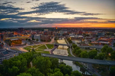
The city of Sioux Falls is coming off a record year in apartment development and is now dealing with growing public concerns about traffic congestion, according to a recent article by Bridget Bennett for KELO.
City of Sioux Falls Traffic Operations Engineer Heath Hoftiezer is quoted in the article saying, “It’s a growing pain thing we’re seeing in all our new neighborhoods.” According to Hoftiezer, about 100 intersections in the city will need to be “signalized” in the next 15 years to conform to federal traffic signal standards. Eventually some of the new developments might also require new access points, as well.
“And like the case of the City’s Edge development, the housing is often complete before the infrastructure that may have attracted it in the first place. Both Southeastern Avenue and Veteran’s Parkway have yet to be built on either side of the large apartment project in the southeast corner of Sioux Falls,” reports Bennett.
No mention of public transit, mixing of uses with retail proximate to the multi-family housing, bike infrastructure, traffic calming, or other methods for congestion reduction and traffic safety are mentioned in the article.
FULL STORY: Traffic growing pains in Sioux Falls’ newest neighborhoods


Planning for Congestion Relief
The third and final installment of Planetizen's examination of the role of the planning profession in both perpetuating and solving traffic congestion.

How Planning Fails to Solve Congestion
Solutions for congestion are never as simple and easy as armchair planners and engineers would like you to believe—especially those who suggest that congestion can be solved by forever building more roadway capacity.

Planning and the Complicated Causes and Effects of Congestion
What do planners know about congestion, and what can they do about it? Explanations and solutions are less obvious than they seem (part one of a three-part series).

Maui's Vacation Rental Debate Turns Ugly
Verbal attacks, misinformation campaigns and fistfights plague a high-stakes debate to convert thousands of vacation rentals into long-term housing.

Planetizen Federal Action Tracker
A weekly monitor of how Trump’s orders and actions are impacting planners and planning in America.

In Urban Planning, AI Prompting Could be the New Design Thinking
Creativity has long been key to great urban design. What if we see AI as our new creative partner?

King County Supportive Housing Program Offers Hope for Unhoused Residents
The county is taking a ‘Housing First’ approach that prioritizes getting people into housing, then offering wraparound supportive services.

Researchers Use AI to Get Clearer Picture of US Housing
Analysts are using artificial intelligence to supercharge their research by allowing them to comb through data faster. Though these AI tools can be error prone, they save time and housing researchers are optimistic about the future.

Making Shared Micromobility More Inclusive
Cities and shared mobility system operators can do more to include people with disabilities in planning and operations, per a new report.
Urban Design for Planners 1: Software Tools
This six-course series explores essential urban design concepts using open source software and equips planners with the tools they need to participate fully in the urban design process.
Planning for Universal Design
Learn the tools for implementing Universal Design in planning regulations.
planning NEXT
Appalachian Highlands Housing Partners
Mpact (founded as Rail~Volution)
City of Camden Redevelopment Agency
City of Astoria
City of Portland
City of Laramie