


land use planning

To Build More Housing, Cities Must Be Smarter in How They Use Land
How strategic land use policy decisions can alleviate the housing crisis and limit unsustainable sprawl.
Montana Land Use Reform Overhauls Public Participation Rules
In a bid to streamline housing permits, new state legislation limits public input to the land use planning stage.
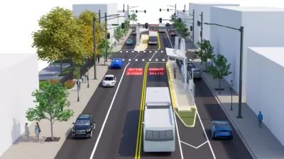
Land Use Changes Could Improve Walkability Along Bus Rapid Transit Corridor in Denver
Denver councilmembers are proposing an overhaul of land use regulations along a long stretch of East Colfax Avenue—the route of a planned Bus Rapid Transit line expected to open in 2026.

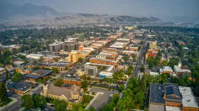
Sioux Falls Multi-Family Development Outpaces Transportation Improvements
Sioux Falls, South Dakota is undergoing a multi-family development boom. Residents are increasingly concerned about the traffic the development brings, according to local news reports.

Study: Renters, Women, Minorities Underrepresented in Land Use Decisions
The membership of decisionmaking bodies such as planning commissions rarely reflects the socioeconomic, gender, and racial characteristics of the local community.

Site Location Snafu Puts Clearwater’s RAISE Grant Funding at Risk
Wires were crossed between the city manager and the city council in Clearwater, Florida, though the city is now back on track with a plan that won $20 million in grant funding from the federal government in August.

Planning for Congestion Relief
The third and final installment of Planetizen's examination of the role of the planning profession in both perpetuating and solving traffic congestion.

What Is LOS?
Level of Service (LOS) defines how well vehicle traffic flows along a street or road. LOS is one of the most influential metrics in planning, with critical relevance for both land use and transportation planning.

How Planning Fails to Solve Congestion
Solutions for congestion are never as simple and easy as armchair planners and engineers would like you to believe—especially those who suggest that congestion can be solved by forever building more roadway capacity.

Where Pro-Development Groups Are Gaining Traction
The YIMBY movement seems to be gaining steam as more the country deals with growing housing prices and increasing numbers of people experiencing homelessness. Recent research reveals where pro-development forces are most likely to call home.

Planning and the Complicated Causes and Effects of Congestion
What do planners know about congestion, and what can they do about it? Explanations and solutions are less obvious than they seem (part one of a three-part series).

Recent Greenfield Developments Build Car Dependency in England, Report Says
The promises of politicians and developers to build more sustainably in the U.K. are going unfulfilled, according to a recent report.
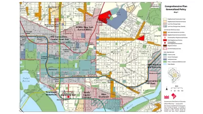
What Are Comprehensive Plans?
The comprehensive plan, sometimes also referred to as a master plan or a general plan, is the foundational document of long-term planning and zoning in the United States.

Inglewood Set to Rezone Neighborhoods Near New Transit Lines
Plans for the area include thousands of new housing units, public parks, and improved bike and pedestrian infrastructure.

Approaching Land Use and Transportation as Interconnected Issues
One researcher argues that the division between transportation and land use policymaking at the federal level has harmed communities of color and encouraged unchecked sprawl.

Parking Induces Driving, Study Says
New research published in the Urban Studies journal does the difficult work of connecting the dots between parking and driving.

Connecting Light Rail Plans to Affordable Housing Opportunities
To keep up with affordable housing demand, Snohomish County needs to add 200,000 units by 2050. Planned light rail stations could be the ticket.

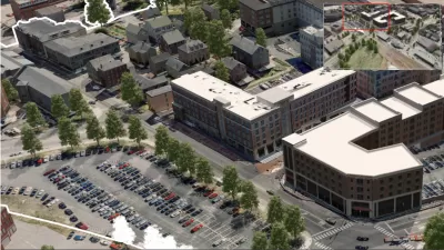
Richmond 300 Plan Update Includes New Cap Park, Form-Based Code
Richmond, Virginia is hoping to make some big changes in time for its tricentennial in 2037, including a new cap park and a new form-based code.
What Is Land Use?
Land use might seem self explanatory, but it has a very specific meaning in the context of U.S. planning history.

Silver Spring Downtown Plan Expanding to Make Room for the Missing Middle
Planners are hoping that by expanding the boundaries of the Silver Spring Downtown Plan in Montgomery County, Maryland, new opportunities for missing middle housing will create new opportunities for housing affordability.
Urban Design for Planners 1: Software Tools
This six-course series explores essential urban design concepts using open source software and equips planners with the tools they need to participate fully in the urban design process.
Planning for Universal Design
Learn the tools for implementing Universal Design in planning regulations.
Heyer Gruel & Associates PA
JM Goldson LLC
Custer County Colorado
City of Camden Redevelopment Agency
City of Astoria
Transportation Research & Education Center (TREC) at Portland State University
Camden Redevelopment Agency
City of Claremont
Municipality of Princeton (NJ)


