


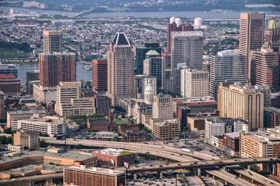
Advocates of highway removal hope the Reconnecting Communities Act will help fund efforts to tear down a freeway that devastated West Baltimore neighborhoods.
Ashley Stimpson’s latest article in Next City begins with an all-too-familiar anecdote: a Black neighborhood, once woven into the surrounding city and its shops, parks, and services, is cut off by a freeway construction project, many of its residents displaced.
In this case, Baltimore’s Interstate 170 did just that to the Rosemont neighborhood in the 1970s. “More than 1,500 residents were displaced; 971 homes, 62 businesses, and one school got the wrecking ball. The area would never recover.” Today, “The sunken highway slashes through the landscape like a deep wound, separating neighborhoods and creating air and noise pollution for nearby residents.”
Now, the city says it will request grant funding through the federal Reconnecting Communities program to tear down the highway, now known as U.S. Route 40. The article describes other notable freeway removal projects, such as Rochester’s East Inner Loop and the removal of a four-lane freeway in Chattanooga.
These projects aren’t without their critics: “Some Rochester residents complained that the East Inner Loop project lacks sufficient green and retail space. Affordable housing is also a concern; new condos along the boulevard are selling for $500,000, while rent for one-bedroom apartments starts at $1,500.” Advocates insist that revitalization without displacement is possible only with the significant participation of the local community. A group called the Connecting Communities in West Baltimore Coalition is lobbying to be the voice of residents in the neighborhood as the city develops its plan for removing and replacing the road.
FULL STORY: Will The Inflation Reduction Act Finally Tear Down Baltimore’s Highway To Nowhere?

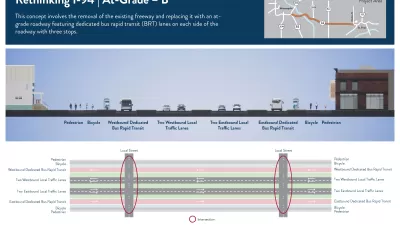
More Options Presented for Minneapolis I-94 Project
Two new proposals for replacing the freeway with at-grade segments offer new visions for the future of downtown Minneapolis.
GAO: Reconnecting Communities Lacks Clear Goals and Metrics
The program, aimed at supporting highway removals and other projects that work to reverse the impacts of freeway construction, is light on accountability and performance measures, according to a new report.
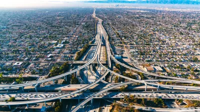
Freeway Removal Projects Gain Momentum
Thanks to decades of activism and newly available federal funding, state and local governments are starting to understand the negative impacts of highway construction and working to reverse the effects on cities around the nation.

Planetizen Federal Action Tracker
A weekly monitor of how Trump’s orders and actions are impacting planners and planning in America.

Map: Where Senate Republicans Want to Sell Your Public Lands
For public land advocates, the Senate Republicans’ proposal to sell millions of acres of public land in the West is “the biggest fight of their careers.”

Restaurant Patios Were a Pandemic Win — Why Were They so Hard to Keep?
Social distancing requirements and changes in travel patterns prompted cities to pilot new uses for street and sidewalk space. Then it got complicated.

Platform Pilsner: Vancouver Transit Agency Releases... a Beer?
TransLink will receive a portion of every sale of the four-pack.

Toronto Weighs Cheaper Transit, Parking Hikes for Major Events
Special event rates would take effect during large festivals, sports games and concerts to ‘discourage driving, manage congestion and free up space for transit.”

Berlin to Consider Car-Free Zone Larger Than Manhattan
The area bound by the 22-mile Ringbahn would still allow 12 uses of a private automobile per year per person, and several other exemptions.
Urban Design for Planners 1: Software Tools
This six-course series explores essential urban design concepts using open source software and equips planners with the tools they need to participate fully in the urban design process.
Planning for Universal Design
Learn the tools for implementing Universal Design in planning regulations.
Heyer Gruel & Associates PA
JM Goldson LLC
Custer County Colorado
City of Camden Redevelopment Agency
City of Astoria
Transportation Research & Education Center (TREC) at Portland State University
Camden Redevelopment Agency
City of Claremont
Municipality of Princeton (NJ)