


Experts say reducing speed limits based on traffic volumes can relieve congestion and improve the flow of traffic.
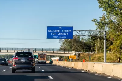
“Hoping to decrease driving delays, last month the Virginia Department of Transportation introduced variable speed limits between mile markers 115 and 130 south of Fredericksburg,” reports Wyatt Gordon in the Virginia Mercury. “Currently, 20 states deploy variable speed limits on at least one stretch of their road networks,” where research shows an average of 5 percent reduction in travel times and 8 percent fewer crashes. “Spaced six-tenths of a mile from one another and at each of the three highway on-ramps along the corridor, the 48 signs each have congestion detectors designed to predict potential traffic problems and drop the speed limit by up to 10 mph per minute.”
The problem variable speed limits seek to solve is called speed flow inversion — the phenomenon whereby even minor interruptions in vehicles’ movement cause extensive congestion due to the density of traffic.
According to Eric Dumbaugh, associate director of the Collaborative Sciences Center for Road Safety at Florida Atlantic University, “This type of technology only works if you have total compliance and a majority, if not all, road users see the sign and adhere to that speed.” The agency is using billboards, signs, and alerts on Waze to alert drivers to the variable speed limits. “The first indications of whether VDOT’s $10 million investment in the new corridor is paying off should come in September, when the agency completes its first round of data on crash rates and types, the frequency of speed reduction, compliance and person-hours of delay.”
FULL STORY: VDOT is introducing variable speed limits, but will congestion care?


Judge Extends NYC Congestion Pricing Through at Least June 9
A federal judge halted the Trump administration’s effort to kill the program, which remains in limbo as a lawsuit filed by the MTA moves forward.

NYC Congestion Pricing Continues to Show Positive Results
While the Trump administration attempts to revoke the program’s federal approval, congestion pricing continues to reduce traffic, speed up bus travel times, and improve air quality in Manhattan.

Philadelphia Is Expanding its Network of Roundabouts
Roundabouts are widely shown to decrease traffic speed, reduce congestion, and improve efficiency.

Planetizen Federal Action Tracker
A weekly monitor of how Trump’s orders and actions are impacting planners and planning in America.

Restaurant Patios Were a Pandemic Win — Why Were They so Hard to Keep?
Social distancing requirements and changes in travel patterns prompted cities to pilot new uses for street and sidewalk space. Then it got complicated.

Maui's Vacation Rental Debate Turns Ugly
Verbal attacks, misinformation campaigns and fistfights plague a high-stakes debate to convert thousands of vacation rentals into long-term housing.

In California Battle of Housing vs. Environment, Housing Just Won
A new state law significantly limits the power of CEQA, an environmental review law that served as a powerful tool for blocking new development.

Boulder Eliminates Parking Minimums Citywide
Officials estimate the cost of building a single underground parking space at up to $100,000.

Orange County, Florida Adopts Largest US “Sprawl Repair” Code
The ‘Orange Code’ seeks to rectify decades of sprawl-inducing, car-oriented development.
Urban Design for Planners 1: Software Tools
This six-course series explores essential urban design concepts using open source software and equips planners with the tools they need to participate fully in the urban design process.
Planning for Universal Design
Learn the tools for implementing Universal Design in planning regulations.
Heyer Gruel & Associates PA
JM Goldson LLC
Custer County Colorado
City of Camden Redevelopment Agency
City of Astoria
Transportation Research & Education Center (TREC) at Portland State University
Camden Redevelopment Agency
City of Claremont
Municipality of Princeton (NJ)