


The Arts District on Santa Fe Drive is considered one of Denver's final frontiers for revitalization. Local stakeholders are targeting zoning changes as a potential solution.
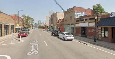
The city of Denver is considering a design overlay district that would require ground floor retail on a ten-block section of the Arts District on Santa Fe Drive.
"Councilwoman Jamie Torres filed a pre-application last summer calling for a design overlay district — essentially a tweak to the area’s zoning — to be established for the stretch of Santa Fe Drive between 3rd and 13th avenues, as well as some additional areas along 8th Avenue," reports Eric Heinz for the Denver Post.
The stretch of Santa Fe Drive in question is "mostly one- to two-story buildings with numerous art galleries, as well as restaurants and small office users," according to Heinz, although recent years have seen larger-scale development pop up along and around the corridor. The goal of the proposed design overlay district is to "maintain the character" of the area, according to Ann Nguyen, a local landscape architect and planner, who is active with the neighborhood association. Nguyen adds that the goal of the district would be to encourage development and activate the corridor more in line with the 'vibe' of other "Main Streets" in the city.
The new design overlay district "would also allow new buildings to sit 10 feet back from the sidewalk to allow more room for pedestrians and outdoor dining," according to Heinz. "Denver is already working on a project that would extend the sidewalk to where there is currently a white stripe along the corridor with white markers."
FULL STORY: Denver may require ground-floor retail in new projects on Santa Fe

Denver Bans 'Slot Homes,' But Not Before They Changed Neighborhoods
Aerial photos show just how completely some areas of the city were transformed before the building typology was eliminated earlier this week.

Denver Takes on Sidewalk Repair
The Colorado capital is the largest U.S. city to commit to maintaining its entire sidewalk network, funding repairs through a fee on property owners.
Denver Pauses Multifamily Development in Westside Neighborhoods Amidst Gentrification Concerns
City officials say the pause on permits for redevelopment projects aims to stop the displacement of long-term residents.

Planetizen Federal Action Tracker
A weekly monitor of how Trump’s orders and actions are impacting planners and planning in America.

Map: Where Senate Republicans Want to Sell Your Public Lands
For public land advocates, the Senate Republicans’ proposal to sell millions of acres of public land in the West is “the biggest fight of their careers.”

Restaurant Patios Were a Pandemic Win — Why Were They so Hard to Keep?
Social distancing requirements and changes in travel patterns prompted cities to pilot new uses for street and sidewalk space. Then it got complicated.

California Homeless Arrests, Citations Spike After Ruling
An investigation reveals that anti-homeless actions increased up to 500% after Grants Pass v. Johnson — even in cities claiming no policy change.

Albuquerque Route 66 Motels Become Affordable Housing
A $4 million city fund is incentivizing developers to breathe new life into derelict midcentury motels.

DC Area County Eliminates Bus Fares
Montgomery County joins a growing trend of making transit free.
Urban Design for Planners 1: Software Tools
This six-course series explores essential urban design concepts using open source software and equips planners with the tools they need to participate fully in the urban design process.
Planning for Universal Design
Learn the tools for implementing Universal Design in planning regulations.
Heyer Gruel & Associates PA
JM Goldson LLC
Custer County Colorado
City of Camden Redevelopment Agency
City of Astoria
Transportation Research & Education Center (TREC) at Portland State University
Camden Redevelopment Agency
City of Claremont
Municipality of Princeton (NJ)