


It's back to the drawing board for the I-5 Rose Quarter Improvement Project.
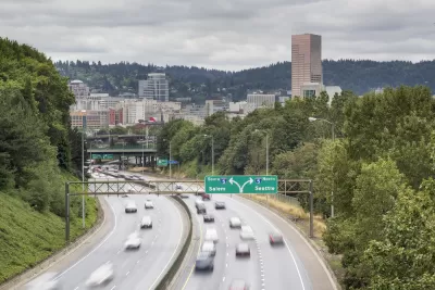
The Oregon Department of Transportation (ODOT) will have to again review the environmental impacts of a proposed freeway widening project on Interstate 5 in the Rose Quarter near Downtown Portland, reports Jayati Ramakrishnan for The Oregonian.
"In a letter to ODOT, made public by the climate activist group No More Freeways, Federal Highway Administration administrator Phillip Ditzler said he rescinded his approval of the environmental assessment because of modifications ODOT made to the I-5 freeway project since he approved the findings in 2020," according to Ramakrishnan.
The modifications in question are a freeway cap:
Those modifications include a freeway cover that would reconnect several blocks in the Albina neighborhood, a historically Black community that was partially razed in the 1960s to build I-5. That plan was approved by the Oregon Transportation Commission in September following a long disagreement between ODOT and local entities, including the community nonprofit Albina Vision Trust, as well as the city and Multnomah County. Those groups had said ODOT’s original plan for freeway covers was inadequate.
The I-5 Rose Quarter Improvement Project, as the freeway widening proposal is called, has been a poster child for the highway widening status quo in recent years, attracting focused criticism after ODOT released an environmental impact assessment in February 2019 that promised the project would deliver air quality and traffic safety improvements.
The source article includes insight into the decision by the Federal Highway Administration and potential next steps for local groups fighting the project.
FULL STORY: ODOT must redo environmental study for Rose Quarter freeway project after feds rescind approval


Plan to Widen I-5 in Portland Loses Critical Local Support
The I-5 Rose Quarter project has proven controversial throughout the study and planning process, and now it's losing key local political support.
Environmental Assessment for I-5 Improvement Project in Portland Promises Air, Traffic, Safety Benefits
The environmental assessment for the I-5 Rose Quarter Improvement Project, released on February 15, 2019, promises to be controversial.
Study: Wider Highways Won't Reduce Congestion
Widening highways won't reduce congestion—that's the conclusion of a report paid for by the state agency proposing several highway widening projects in Oregon.

Maui's Vacation Rental Debate Turns Ugly
Verbal attacks, misinformation campaigns and fistfights plague a high-stakes debate to convert thousands of vacation rentals into long-term housing.

Planetizen Federal Action Tracker
A weekly monitor of how Trump’s orders and actions are impacting planners and planning in America.

San Francisco Suspends Traffic Calming Amidst Record Deaths
Citing “a challenging fiscal landscape,” the city will cease the program on the heels of 42 traffic deaths, including 24 pedestrians.

Defunct Pittsburgh Power Plant to Become Residential Tower
A decommissioned steam heat plant will be redeveloped into almost 100 affordable housing units.

Trump Prompts Restructuring of Transportation Research Board in “Unprecedented Overreach”
The TRB has eliminated more than half of its committees including those focused on climate, equity, and cities.

Amtrak Rolls Out New Orleans to Alabama “Mardi Gras” Train
The new service will operate morning and evening departures between Mobile and New Orleans.
Urban Design for Planners 1: Software Tools
This six-course series explores essential urban design concepts using open source software and equips planners with the tools they need to participate fully in the urban design process.
Planning for Universal Design
Learn the tools for implementing Universal Design in planning regulations.
Heyer Gruel & Associates PA
JM Goldson LLC
Custer County Colorado
City of Camden Redevelopment Agency
City of Astoria
Transportation Research & Education Center (TREC) at Portland State University
Jefferson Parish Government
Camden Redevelopment Agency
City of Claremont