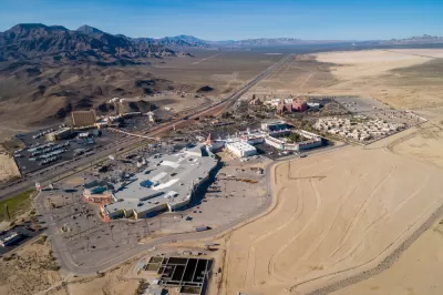
A $12 million repaving and restriping project is intended to alleviate congestion at the state line between California and Nevada, just outside of Las Vegas.

"A 5-mile stretch of Interstate 15 south of the Nevada state line will be widened this spring in an effort to eliminate a frustrating bottleneck that has caused miles of backups for travelers to California," reports Bryan Rokos for The Sun.
In a separate article for the Las Vegas Sun, Ray Brewer provides additional news coverage of the plan to widen I-15 at the border between the two states by repaving and restriping the right shoulder for use as a third lane between the border and the California Department of Food and Agriculture station during peak traffic periods—Sunday and Monday, in this case.
California Governor Gavin Newsom and Nevada Governor Steve Sisolak made a joint announcement about the $12 million project at a press conference held next to the freeway near the border. Both governors touted the importance of the corridor, and the connections caused by the bottleneck at state lines.
"This stretch of highway between the Nevada border and the California Department of Food and Agriculture Agricultural Station is federally recognized as an economic lifeline corridor due to its role in the supply chain, and for connecting the economic and tourism hubs of Southern California and Las Vegas," writes Rokos.
The project is not, as noted in both article, a long-term solution for congestion between Los Angeles and Las Vegas—where two competing visions for connecting the two regions are in disparate states of speculation. A plan to build a high-speed rail route between Las Vegas and Southern California was shelved in November 2020, while many officials in Las Vegas are pushing for the state to use its funding from the federal infrastructure bill, officially known as the Infrastructure Investment and Jobs Act, on the I-15 corridor between the two states.
FULL STORY: Newsom: Southbound I-15 near Nevada line will be widened to alleviate traffic jams

Planetizen Federal Action Tracker
A weekly monitor of how Trump’s orders and actions are impacting planners and planning in America.

Maui's Vacation Rental Debate Turns Ugly
Verbal attacks, misinformation campaigns and fistfights plague a high-stakes debate to convert thousands of vacation rentals into long-term housing.

San Francisco Suspends Traffic Calming Amidst Record Deaths
Citing “a challenging fiscal landscape,” the city will cease the program on the heels of 42 traffic deaths, including 24 pedestrians.

Amtrak Rolls Out New Orleans to Alabama “Mardi Gras” Train
The new service will operate morning and evening departures between Mobile and New Orleans.

The Subversive Car-Free Guide to Trump's Great American Road Trip
Car-free ways to access Chicagoland’s best tourist attractions.

San Antonio and Austin are Fusing Into one Massive Megaregion
The region spanning the two central Texas cities is growing fast, posing challenges for local infrastructure and water supplies.
Urban Design for Planners 1: Software Tools
This six-course series explores essential urban design concepts using open source software and equips planners with the tools they need to participate fully in the urban design process.
Planning for Universal Design
Learn the tools for implementing Universal Design in planning regulations.
Heyer Gruel & Associates PA
JM Goldson LLC
Custer County Colorado
City of Camden Redevelopment Agency
City of Astoria
Transportation Research & Education Center (TREC) at Portland State University
Jefferson Parish Government
Camden Redevelopment Agency
City of Claremont


