


Doubters questioned whether Atlanta had the political will to bring the Beltline to the Southside. The city overcame those doubts last week.
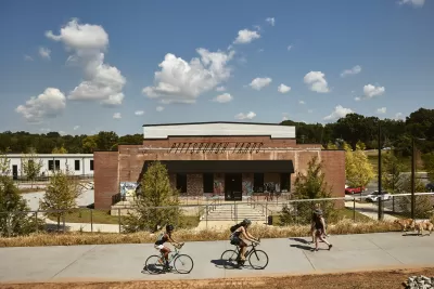
"The first segment of the Atlanta Beltline running along the Southside of the city is now open to the public," reports J.D. Capelouto.
The new section of the popular trail, called the Southside Trail, opened on Tuesday, October 12, with a gathering of public officials including Mayor Keisha Bottoms.
Capelouto shares the key stats for the new section of the Beltline: "The mixed-use path runs for 0.8 miles from the existing Westside Trail at the end of University Avenue to Pittsburgh Yards, just west of the I-75/85 overpass."
The remainder of the Southside Trail is open but in an unfinished state as design and planning work continues. In the meantime, the new section of the Southside Trail is a step toward a grand final vision: "City leaders heralded the Southside Trail opening as the first step toward a connected, paved route from the Eastside to the Westside."
More on the significance of the new Southside Trail can be found in the source article.
FULL STORY: The first stretch of the Beltline’s Southside Trail is now open

New Study Commissioned for Atlanta BeltLine Transit
The study will assess alignment options for a 13-mile segment of the greenway.

Affordable Housing Funding Reaches New Heights for Beltline Neighborhoods
The city of Atlanta has allocated $11.9 million of its $45 million budget for the Beltline for affordable housing.
Friday Eye Candy: New Renderings for the Atlanta BeltLine's Westside Trail
Atlanta's BeltLine is one of the country's most exciting public space projects, and residents have even more reason for excitement after Beltline.org released a fresh batch of renderings for the forthcoming expansion of the Westside Trail.

Maui's Vacation Rental Debate Turns Ugly
Verbal attacks, misinformation campaigns and fistfights plague a high-stakes debate to convert thousands of vacation rentals into long-term housing.

Planetizen Federal Action Tracker
A weekly monitor of how Trump’s orders and actions are impacting planners and planning in America.

In Urban Planning, AI Prompting Could be the New Design Thinking
Creativity has long been key to great urban design. What if we see AI as our new creative partner?

King County Supportive Housing Program Offers Hope for Unhoused Residents
The county is taking a ‘Housing First’ approach that prioritizes getting people into housing, then offering wraparound supportive services.

Researchers Use AI to Get Clearer Picture of US Housing
Analysts are using artificial intelligence to supercharge their research by allowing them to comb through data faster. Though these AI tools can be error prone, they save time and housing researchers are optimistic about the future.

Making Shared Micromobility More Inclusive
Cities and shared mobility system operators can do more to include people with disabilities in planning and operations, per a new report.
Urban Design for Planners 1: Software Tools
This six-course series explores essential urban design concepts using open source software and equips planners with the tools they need to participate fully in the urban design process.
Planning for Universal Design
Learn the tools for implementing Universal Design in planning regulations.
planning NEXT
Appalachian Highlands Housing Partners
Mpact (founded as Rail~Volution)
City of Camden Redevelopment Agency
City of Astoria
City of Portland
City of Laramie