


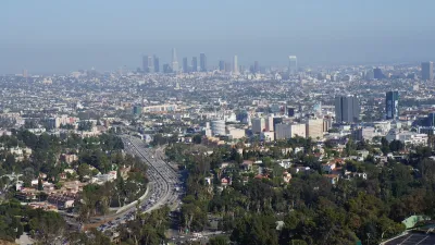
Google has unveiled a new tool called Tree Canopy Lab in an effort to keep cities like Los Angeles cool by helping them to know where to plant more trees.

Many of us would probably agree that planting more trees is a good thing. Cities tend to be warmer than surrounding areas because buildings and asphalt trap heat, resulting in the urban heat island effect. One way to cool urban areas down is to plant more trees in neighborhoods where they are sparse.
The challenge is knowing where to plant trees strategically to benefit those who need them most. As Justine Calma explains in this article, Google has released a tool that can help. Specifically, Google's new Tree Canopy Lab can help cities keep their residents cool by mapping out where trees are needed most.
Tree Canopy Lab uses aerial imagery and Google’s artificial intelligence to figure out where every tree is in a city. The tool then puts that information on an interactive map along with additional data layers on which neighborhoods are more densely populated and are more vulnerable to high temperatures. The idea is that planting new trees in these areas can help cities adapt to a warming world and save lives during heat waves.
Google piloted Tree Canopy Lab in Los Angeles. Data on hundreds more cities is on the way. Tree Canopy Lab found that over half of L.A. residents live in places where trees shade less than 10 percent of their neighborhood. It also found that 44 percent of Angelenos live in places with extreme heat risk. Heat waves in Los Angeles County have gotten longer, more frequent, and more intense over the past 50 years.
FULL STORY: Google launches new tool to help cities stay cool

Updating LA’s Tree Rules Could Bring More Shade to Underserved Neighborhoods
A new USC study finds that relaxing Los Angeles’ outdated tree planting guidelines could significantly expand urban tree canopy and reduce shade disparities in lower-income neighborhoods, though infrastructure investments are also needed.

Improving South Los Angeles Through Strategic Tree Planting
The University of Southern California Urban Trees Initiative is planting 250 trees in South L.A. neighborhoods to improve shade, combat climate change, and enhance community well-being through collaboration and data-driven approaches.
Invasive Beetles Put Oregon Forests at Risk
Two recently discovered borer beetles could lead to a significant loss of tree canopy.

Planetizen Federal Action Tracker
A weekly monitor of how Trump’s orders and actions are impacting planners and planning in America.

Map: Where Senate Republicans Want to Sell Your Public Lands
For public land advocates, the Senate Republicans’ proposal to sell millions of acres of public land in the West is “the biggest fight of their careers.”

Restaurant Patios Were a Pandemic Win — Why Were They so Hard to Keep?
Social distancing requirements and changes in travel patterns prompted cities to pilot new uses for street and sidewalk space. Then it got complicated.

Platform Pilsner: Vancouver Transit Agency Releases... a Beer?
TransLink will receive a portion of every sale of the four-pack.

Toronto Weighs Cheaper Transit, Parking Hikes for Major Events
Special event rates would take effect during large festivals, sports games and concerts to ‘discourage driving, manage congestion and free up space for transit.”

Berlin to Consider Car-Free Zone Larger Than Manhattan
The area bound by the 22-mile Ringbahn would still allow 12 uses of a private automobile per year per person, and several other exemptions.
Urban Design for Planners 1: Software Tools
This six-course series explores essential urban design concepts using open source software and equips planners with the tools they need to participate fully in the urban design process.
Planning for Universal Design
Learn the tools for implementing Universal Design in planning regulations.
Heyer Gruel & Associates PA
JM Goldson LLC
Custer County Colorado
City of Camden Redevelopment Agency
City of Astoria
Transportation Research & Education Center (TREC) at Portland State University
Camden Redevelopment Agency
City of Claremont
Municipality of Princeton (NJ)