


Google's plan for a mixed-use transit village at a mile-long site near the Diridon Station in San Jose has a newly released planning document available for public review.
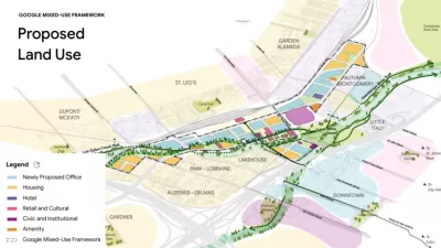
[Updated October 14, 2020] The city of San Jose released hundreds of pages of documents detailing the Downtown West Mixed-Use Plan, Google's plan to "develop 81 acres in downtown San Jose into a transit-oriented area consisting of new office space, housing and open space," as described in an article by Jenn Goodman.
"Google's revised project proposal includes up to 7.3 million square feet of office space; 4,000 units of new housing; 15 acres of parks and open space; and 500,000 square feet of retail, culture and art space, among other features," according to Goodman. SITELAB urban studio is the lead urban designer for the Downtown West Mixed Use Plan, and created the design standards and guidelines released by the city this month.
A previous iteration of the plan was released in September as a Framework Plan for the Diridon Transit Village. The new plan will require several related entitlements and approvals, namely a general plan amendment, an amendment to the Diridon Station Area Plan, a Planned Development Zoning District, a Planned Development Permit, and an environmental impact review, among others. The plan is also proceeding under state law AB 900, with certification from the Governor's Office that the Downtown West Mixed-Use Plan would not result in any net additional greenhouse gas (GHG) emissions.
The coronavirus pandemic has delayed the project's review by a few months, but plans are expected to be before the San Jose City Council for approval in Spring 2021.
Previous Planetizen coverage of Google's plans for the Downtown San Jose development proximate to the Diridon Transit Station:
- Google Planning Massive Expansion in San Jose (June 2017)
- Google's Second Headquarters and the Future of San Jose (December 2017)
- Google's San Jose Transit Village Plans Revealed (September 2019)
FULL STORY: Google details 80-acre mixed-use project in San Jose, CA

Google's San Jose Transit Village Plans Revealed
Google's plans for the Diridon Transit Village are much more clear.

Google Continues to Expand in San Jose
Google has laid the foundation for four large, and distinct, employment centers in just one city of the South Bay Area.
Google Expanding its Presence in San Jose
Google has expanded its footprint in North San Jose to cover 1.27 million square feet. Local officials are saying that the company's acquisitions ensure the long-term financial stability of the city.

Planetizen Federal Action Tracker
A weekly monitor of how Trump’s orders and actions are impacting planners and planning in America.

Restaurant Patios Were a Pandemic Win — Why Were They so Hard to Keep?
Social distancing requirements and changes in travel patterns prompted cities to pilot new uses for street and sidewalk space. Then it got complicated.

Maui's Vacation Rental Debate Turns Ugly
Verbal attacks, misinformation campaigns and fistfights plague a high-stakes debate to convert thousands of vacation rentals into long-term housing.

In California Battle of Housing vs. Environment, Housing Just Won
A new state law significantly limits the power of CEQA, an environmental review law that served as a powerful tool for blocking new development.

Boulder Eliminates Parking Minimums Citywide
Officials estimate the cost of building a single underground parking space at up to $100,000.

Orange County, Florida Adopts Largest US “Sprawl Repair” Code
The ‘Orange Code’ seeks to rectify decades of sprawl-inducing, car-oriented development.
Urban Design for Planners 1: Software Tools
This six-course series explores essential urban design concepts using open source software and equips planners with the tools they need to participate fully in the urban design process.
Planning for Universal Design
Learn the tools for implementing Universal Design in planning regulations.
Heyer Gruel & Associates PA
JM Goldson LLC
Custer County Colorado
City of Camden Redevelopment Agency
City of Astoria
Transportation Research & Education Center (TREC) at Portland State University
Camden Redevelopment Agency
City of Claremont
Municipality of Princeton (NJ)