


Advocates are calling out regional and state transportation planning agencies for a failure of racial justice as plans to widen a freeway in Southern California move forward.
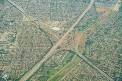
Joe Linton reports: "The full details are not yet entirely clear, but Metro and Caltrans are finalizing plans to widen portions of the 605 and 5 Freeways – and the project will destroy hundreds of homes, primarily in the city of Downey."
The "I-605 Corridor Improvement Project," as it's known at the Los Angeles County Metropolitan Transportation Authority (Metro) would work on portions of the I-5, I-10, I-105, and California State Route 60, in addition to I-605, while crossing jurisdictional lines and touching nine cities and additional unincorporated areas, according to Linton.
The possibility of the highway widening encroaching on existing residential properties is found in the project alternatives from an August presentation for Metro’s $10 billion SR-91/I-605/I-405 “Hot Spots” Program. All three of the current project alternatives under consideration by metro would add two additional lanes to each side of the 605 Freeway, according to Linton.
A chart in the presentation lists the number of parcels to be acquired by Metro and Caltrans to make space for the new lanes: 360+ full acquisitions, 320+ partial acquisitions, and 540+ easements.
Linton gives a hat tip to Downey resident Alexandria Contreras, who raised the alarm about the project's plans to expand into existing private properties via Twitter. Mainstream local news has also picked up the story, like this on-air report by NBC Los Angeles.
A lot more detail, maps, and soundbites are found in the source article.
FULL STORY: Metro Plans to Take Out 200+ Downey Homes to Widen 5 and 605 Freeways

Not So Fast: Metro Board Hits the Brakes on Southern California Highway Expansion Plans
Political opposition to the controversial I-605 Corridor Improvement Project is gaining traction on the Los Angeles County Metropolitan Transportation Authority Board of Directors.
L.A. Metro Denounces—but Doesn't Scrap—710 Freeway Expansion Plan
The agency's board members spoke out forcefully against air pollution and displacement, but stopped short of completely rejecting the project, looking instead to cleaner vehicles and regulations that mitigate community concerns.
Opinion: LA Should Reject ‘Misguided’ Car-Centric Policies
Even as the city highlights clean energy and transportation for the 2028 Olympics, Metro and Caltrans move forward with plans to expand highways.

Maui's Vacation Rental Debate Turns Ugly
Verbal attacks, misinformation campaigns and fistfights plague a high-stakes debate to convert thousands of vacation rentals into long-term housing.

Planetizen Federal Action Tracker
A weekly monitor of how Trump’s orders and actions are impacting planners and planning in America.

San Francisco Suspends Traffic Calming Amidst Record Deaths
Citing “a challenging fiscal landscape,” the city will cease the program on the heels of 42 traffic deaths, including 24 pedestrians.

Defunct Pittsburgh Power Plant to Become Residential Tower
A decommissioned steam heat plant will be redeveloped into almost 100 affordable housing units.

Trump Prompts Restructuring of Transportation Research Board in “Unprecedented Overreach”
The TRB has eliminated more than half of its committees including those focused on climate, equity, and cities.

Amtrak Rolls Out New Orleans to Alabama “Mardi Gras” Train
The new service will operate morning and evening departures between Mobile and New Orleans.
Urban Design for Planners 1: Software Tools
This six-course series explores essential urban design concepts using open source software and equips planners with the tools they need to participate fully in the urban design process.
Planning for Universal Design
Learn the tools for implementing Universal Design in planning regulations.
Heyer Gruel & Associates PA
JM Goldson LLC
Custer County Colorado
City of Camden Redevelopment Agency
City of Astoria
Transportation Research & Education Center (TREC) at Portland State University
Jefferson Parish Government
Camden Redevelopment Agency
City of Claremont