


Vision 2030 will update the award winning Vision 2020 New York City Comprehensive Waterfront Plan.
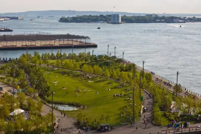
The city of New York is seeking public feedback on the Vision 2030 update of the New York City Comprehensive Plan, the first update since the Vision 2020 earned Daniel Burnham Award for a Comprehensive Plan from the American Planning Association in 2012.
The New York City Department of City Planning is mandated by a 2008 law to update the Comprehensive Waterfront Plan every ten years. The Vision 2030 update promises to make New York City’s 520 miles of waterfront more accessible, active, and resilient by building on the work of the Vision 2020 plan to provide public access the city's waterways, adapt the city's densely populated coastal areas to the effects of climate change, and support economic activity along the waterfront, among other goals.
The city is also hosting #WaterfrontWednesday virtual events to continue the public engagement process during the pandemic.
The Vision 2030 New York City Comprehensive Waterfront Plan is expected for completion by the end of 2020.

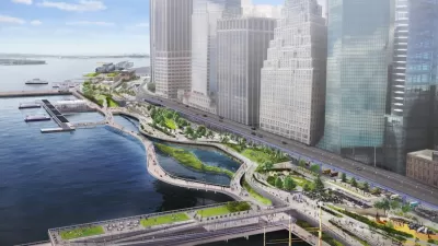
Lower Manhattan Climate Resilience Plan Released
The Financial District and Seaport Climate Resilience Master Plan will extend the shoreline in Lower Manhattan by up to 200 feet.
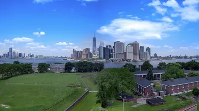
Finalists Selected for Governors Island Climate Research Center
Four teams will submit detailed proposals for a new climate research and education center on New York's Governors Island.

'Daylighting' Project to Restore Nature in the Big Apple
More cities are returning waterways to a more natural state—in some cases unearthing them from subterranean pipes in a process known as "daylighting." A new example can be found, perhaps surprisingly, in New York City.

Maui's Vacation Rental Debate Turns Ugly
Verbal attacks, misinformation campaigns and fistfights plague a high-stakes debate to convert thousands of vacation rentals into long-term housing.

Planetizen Federal Action Tracker
A weekly monitor of how Trump’s orders and actions are impacting planners and planning in America.

San Francisco Suspends Traffic Calming Amidst Record Deaths
Citing “a challenging fiscal landscape,” the city will cease the program on the heels of 42 traffic deaths, including 24 pedestrians.

Defunct Pittsburgh Power Plant to Become Residential Tower
A decommissioned steam heat plant will be redeveloped into almost 100 affordable housing units.

Trump Prompts Restructuring of Transportation Research Board in “Unprecedented Overreach”
The TRB has eliminated more than half of its committees including those focused on climate, equity, and cities.

Amtrak Rolls Out New Orleans to Alabama “Mardi Gras” Train
The new service will operate morning and evening departures between Mobile and New Orleans.
Urban Design for Planners 1: Software Tools
This six-course series explores essential urban design concepts using open source software and equips planners with the tools they need to participate fully in the urban design process.
Planning for Universal Design
Learn the tools for implementing Universal Design in planning regulations.
Heyer Gruel & Associates PA
JM Goldson LLC
Custer County Colorado
City of Camden Redevelopment Agency
City of Astoria
Transportation Research & Education Center (TREC) at Portland State University
Jefferson Parish Government
Camden Redevelopment Agency
City of Claremont