


In the Twin Cities, traffic engineers are reconsidering traffic congestion on four-lane arterials in the face of unrelenting tragedy on these car-centric corridors. Road diets, designed for safety, are now a more tenable proposition.
Bill Lendeke reports from the Twin Cities region in Minnesota, where traffic fatalities are pressuring local officials to commit to changes on unsafe four-lane arterials where drivers inflict the most damage.
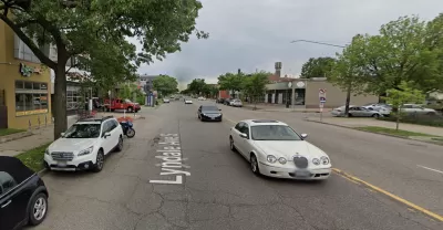
Lyndale Avenue in provides the scene for the story, as the location of a recent tragedy where a driver struck and killed 54-year-old Theodore Ferrera on October 13.
At first glance, the idea of change on Lyndale might seem hopeless. The Hennepin County arterial street has very high traffic volumes — more than 24,000 cars a day. But recent moves by Ramsey and Hennepin Counties this year are signs that the conventional wisdom about four-lane roads might be changing. Both counties have become more aggressive about implementing three-lane “road diets,” as engineers and policy makers have begun to push the boundaries of where safety measures might work. These new designs, on streets like Broadway NE and Maryland Avenue, might be a sign of a safer approach to urban streets in the Twin Cities.
According to Lindeke, four-lane, undivided roads in walkable urban neighborhoods are the most deadly streets in the region. The street design is intended to give cars room to speed and maneuver around slower or stopped vehicles. Adding pedestrians to the mix has deadly consequences. It took a certain traffic volume, below 16,000 car trips a day, to convince traffic engineers to commit to a road diet on streets like this in the region, due to the desire to keep moving cars traffic moving at high speeds. The old traffic regime, however, is coming to end.
"This year, at least in the Twin Cities, the industry standards are beginning to change. In the wake of persistent crashes, first Ramsey and now Hennepin County are implementing four-to-three-lane conversions on arterials with far more traffic than in years past," explains Lindeke.
FULL STORY: Risky Hennepin and Ramsey County streets are increasingly being put on ‘road diets’


How One Minnesota County Cut Homelessness by 80 Percent
While homelessness rose in most U.S. regions, Hennepin County invested heavily in programs to end chronic homelessness and get people into temporary and supportive housing faster.

'20 Is Plenty' in the Twin Cities
The first 20 mile per hour speed limit signs have been installed this week in the Twin Cities.

Nation's Top Safety Board Recommends Protected Bike Lanes
The NTSB chair issued a stark warning on Nov. 5: "If we do not improve roadway infrastructure for bicyclists, bicyclists will die who otherwise would not," stated Robert Sumwalt in introducing their first report in 47 years devoted to bike safety.

Planetizen Federal Action Tracker
A weekly monitor of how Trump’s orders and actions are impacting planners and planning in America.

Maui's Vacation Rental Debate Turns Ugly
Verbal attacks, misinformation campaigns and fistfights plague a high-stakes debate to convert thousands of vacation rentals into long-term housing.

Restaurant Patios Were a Pandemic Win — Why Were They so Hard to Keep?
Social distancing requirements and changes in travel patterns prompted cities to pilot new uses for street and sidewalk space. Then it got complicated.

In California Battle of Housing vs. Environment, Housing Just Won
A new state law significantly limits the power of CEQA, an environmental review law that served as a powerful tool for blocking new development.

Boulder Eliminates Parking Minimums Citywide
Officials estimate the cost of building a single underground parking space at up to $100,000.

Orange County, Florida Adopts Largest US “Sprawl Repair” Code
The ‘Orange Code’ seeks to rectify decades of sprawl-inducing, car-oriented development.
Urban Design for Planners 1: Software Tools
This six-course series explores essential urban design concepts using open source software and equips planners with the tools they need to participate fully in the urban design process.
Planning for Universal Design
Learn the tools for implementing Universal Design in planning regulations.
Heyer Gruel & Associates PA
JM Goldson LLC
Custer County Colorado
City of Camden Redevelopment Agency
City of Astoria
Transportation Research & Education Center (TREC) at Portland State University
Jefferson Parish Government
Camden Redevelopment Agency
City of Claremont