


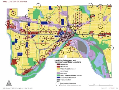
The St. Paul 2040 Comprehensive Plan aims for missing middle density at 56 "Neighborhood Nodes" around the city.
Frederick Melo reports on the details of the new 20-year comprehensive plan for St. Paul, under consideration at a series of public meetings this month and expected for a City Council by January.
According to Melo, the "St. Paul for All 2040 Comprehensive Plan" focuses growth around "Neighborhood Nodes":
St. Paul wants and needs to grow, and to do that, city planners have pinpointed 56 intersections where denser new housing, retail, transit stops and other important services could happily co-exist. That may mean lifting zoning and density restrictions, or taking advantage of zoning that already exists, to incorporate these future “neighborhood nodes” into local planning.
The entire comprehensive plan is split into six chapters, on land use, transportation, parks and open space, housing, water resources, and historic preservation, according to Melo's explanation. "The chapters touch on six themes — urban design, economic development, resiliency in the face of intense environmental changes, public health, helping residents remain in their neighborhoods as they age, and reducing racial disparities through equitable distribution of city services."
FULL STORY: St. Paul’s 20-year plan calls for more development at 56 neighborhood intersections


Charlotte's New, Controversial Comprehensive Plan to End Single-Family Zoning
A tight vote after months of controversy has produced a major zoning reform effort that differs significantly from recent examples on the West Coast and in Minneapolis.

D.C. Comprehensive Plan Amendments Approved
New amendments to the D.C. Comprehensive Plan set goals for new housing development and fewer cars on the road.
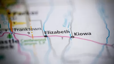
Rapid Growth and a Small Town Recall Effort
A group of organizers in the small town of Elizabeth, Colorado (population 1,700) wants to recall its entire City Council as an act of defiance in the face of rapid change and growth.

Planetizen Federal Action Tracker
A weekly monitor of how Trump’s orders and actions are impacting planners and planning in America.

Map: Where Senate Republicans Want to Sell Your Public Lands
For public land advocates, the Senate Republicans’ proposal to sell millions of acres of public land in the West is “the biggest fight of their careers.”

Restaurant Patios Were a Pandemic Win — Why Were They so Hard to Keep?
Social distancing requirements and changes in travel patterns prompted cities to pilot new uses for street and sidewalk space. Then it got complicated.

Platform Pilsner: Vancouver Transit Agency Releases... a Beer?
TransLink will receive a portion of every sale of the four-pack.

Toronto Weighs Cheaper Transit, Parking Hikes for Major Events
Special event rates would take effect during large festivals, sports games and concerts to ‘discourage driving, manage congestion and free up space for transit.”

Berlin to Consider Car-Free Zone Larger Than Manhattan
The area bound by the 22-mile Ringbahn would still allow 12 uses of a private automobile per year per person, and several other exemptions.
Urban Design for Planners 1: Software Tools
This six-course series explores essential urban design concepts using open source software and equips planners with the tools they need to participate fully in the urban design process.
Planning for Universal Design
Learn the tools for implementing Universal Design in planning regulations.
Heyer Gruel & Associates PA
JM Goldson LLC
Custer County Colorado
City of Camden Redevelopment Agency
City of Astoria
Transportation Research & Education Center (TREC) at Portland State University
Camden Redevelopment Agency
City of Claremont
Municipality of Princeton (NJ)