


Monday marked the first time King County Metro Transit has deployed its almost-decade-old plan to deal with winter conditions.
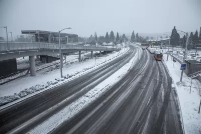
"Monday is the first commute day that King County Metro Transit has implemented its 'Emergency Snow Network,' which reduced the usual 237 routes to just 60 high-ridership, low-slope bus corridors [pdf]," reports Mike Lindbloom.
"Overall trips are about 40 percent of normal, on routes that normally carry 65 percent of Metro’s ridership of just more than 400,000 boardings per day, the agency says. That means many commuters on local routes, for instance in steep areas like Queen Anne Hill, often walk to busier routes," adds Linblom.
The city's Emergency Snow Network plan was created after a December 2008 storm. At the time, the city "treated the roads with sand, not salt, and Metro improvised by cutting service in half."
"At one point, 200 buses were abandoned on streets and Metro estimated a $1.5 million loss for damage and worker overtime."
FULL STORY: Which Metro buses are running during Seattle’s big snowstorm?


Shared Mobility Riders in Seattle to Get Free Transit Trips
Riders who park Lime bikes or scooters at one of 14 designated Link light rail stations can earn free trips on the region’s transit systems.

Sooner Rather Than Later: Support Builds for Eastside-Only Light Rail in Seattle
The Eastside Link light rail route, now known as Line 2, is delayed. A Sound Transit board officials is suggesting that some of the route can open soon, while the rest of the route is prepped to open later.
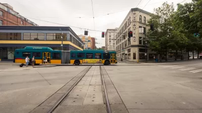
A ‘Playbook’ for Better Bus Service, From King County Metro
King County Metro operates one of the nation’s busiest transit systems—without running any trains. The agency recently released a playbook as a guide to transit service.

Maui's Vacation Rental Debate Turns Ugly
Verbal attacks, misinformation campaigns and fistfights plague a high-stakes debate to convert thousands of vacation rentals into long-term housing.

Planetizen Federal Action Tracker
A weekly monitor of how Trump’s orders and actions are impacting planners and planning in America.

In Urban Planning, AI Prompting Could be the New Design Thinking
Creativity has long been key to great urban design. What if we see AI as our new creative partner?

King County Supportive Housing Program Offers Hope for Unhoused Residents
The county is taking a ‘Housing First’ approach that prioritizes getting people into housing, then offering wraparound supportive services.

Researchers Use AI to Get Clearer Picture of US Housing
Analysts are using artificial intelligence to supercharge their research by allowing them to comb through data faster. Though these AI tools can be error prone, they save time and housing researchers are optimistic about the future.

Making Shared Micromobility More Inclusive
Cities and shared mobility system operators can do more to include people with disabilities in planning and operations, per a new report.
Urban Design for Planners 1: Software Tools
This six-course series explores essential urban design concepts using open source software and equips planners with the tools they need to participate fully in the urban design process.
Planning for Universal Design
Learn the tools for implementing Universal Design in planning regulations.
planning NEXT
Appalachian Highlands Housing Partners
Mpact (founded as Rail~Volution)
City of Camden Redevelopment Agency
City of Astoria
City of Portland
City of Laramie