


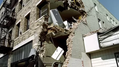
A new earthquake warning system is in place in the city of Los Angeles.

The Associated Press reports on the details of a new earthquake warning app available to Los Angeles County residents.
The app, called ShakeAlertLA will send an alert that could arrive before, during, or after an earthquake of at least 5.0 magnitude on the Richter scale.
The ShakeAlertLA app is based on a warning system developed by the U.S. Geological Survey. Several cities and agencies around the country already have earthquake warning systems, as do cities in Mexico and Japan, but this is the first time an earthquake warning system is available to the general public in the United States.
For more information on the new app, see also an article by Alissa Walker from August 2018.
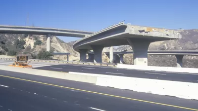
Earthquake readiness was a big component of the "Resilient Los Angeles" plan released in March 2018 as a result of funding from the 100 Resilient Cities network, funded by the Rockefeller Foundation.
FULL STORY: Los Angeles unveils earthquake warning app

Retrofitting Vulnerable Buildings Becomes Mandatory in Earthquake Prone LA..
Decades in the making, the Los Angeles City Council has approved regulations requiring the retrofit of vulnerable wood and concrete buildings.
Resilient Los Angeles: Preparing for Overlapping Disasters in Pandemic
L.A. City Chief Resilience Officer Aaron Gross elaborates on how the pandemic is shaping the city’s understanding of resilience and the cascading impact that overlapping disasters of earthquake or wildfire could have on the city’s limited resources.
Five Years of 100 Resilient Cities
It's been five years since the Rockefeller Foundation launched the 100 Resilient Cities initiative. A new analysis by the Urban Institute evaluates the accomplishments of 100 Resilient Cities so far.

Maui's Vacation Rental Debate Turns Ugly
Verbal attacks, misinformation campaigns and fistfights plague a high-stakes debate to convert thousands of vacation rentals into long-term housing.

Planetizen Federal Action Tracker
A weekly monitor of how Trump’s orders and actions are impacting planners and planning in America.

In Urban Planning, AI Prompting Could be the New Design Thinking
Creativity has long been key to great urban design. What if we see AI as our new creative partner?

Cal Fire Chatbot Fails to Answer Basic Questions
An AI chatbot designed to provide information about wildfires can’t answer questions about evacuation orders, among other problems.

What Happens if Trump Kills Section 8?
The Trump admin aims to slash federal rental aid by nearly half and shift distribution to states. Experts warn this could spike homelessness and destabilize communities nationwide.

Sean Duffy Targets Rainbow Crosswalks in Road Safety Efforts
Despite evidence that colorful crosswalks actually improve intersection safety — and the lack of almost any crosswalks at all on the nation’s most dangerous arterial roads — U.S. Transportation Secretary Duffy is calling on states to remove them.
Urban Design for Planners 1: Software Tools
This six-course series explores essential urban design concepts using open source software and equips planners with the tools they need to participate fully in the urban design process.
Planning for Universal Design
Learn the tools for implementing Universal Design in planning regulations.
Appalachian Highlands Housing Partners
Gallatin County Department of Planning & Community Development
Heyer Gruel & Associates PA
Mpact (founded as Rail~Volution)
City of Camden Redevelopment Agency
City of Astoria
City of Portland
City of Laramie