


The eternal battle between jurisdictions over how to control flooding along the Mississippi River continues.

"A plan to build a port in Lincoln County, including a retail center and industrial lots, is moving forward, despite strong opposition from its much-larger neighbor," reports Leah Thorsen.
"The ambitious project in the works for several years has drawn the ire of the St. Charles County Council, which this month passed a resolution opposing any legislation that would support the Port of Lincoln," adds Thorsen. Lincoln County is located just upriver from St. Charles County, both on the Missouri side of the Mississippi River.
According to the article, St. Charles County's concerns center on flooding concerns by raising the flood plain and further constricting the Mississippi River.
The proposed site of the port is the result of a commodity movement study completed by the Boonslick Regional Planning Commission.
FULL STORY: Flood worries prompt St. Charles County opposition to port plan

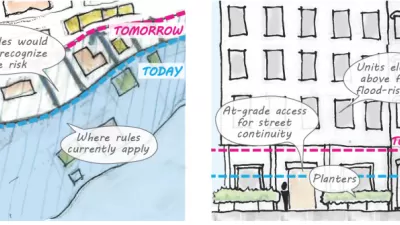
'Zoning for Coastal Flood Resiliency' Wins Planning Commission Approval in NYC
Emergency responses to Hurricane Sandy have turned into long-term lessons in New York City, as the nation's largest city crafts a response to sea-level rise and extreme weather by making changes to the zoning code of coastal areas.
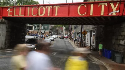
When the Floodwaters Receded in Ellicott City
Ellicott City, Maryland, a suburb located 12-miles from Baltimore with a historic Main Street that has experienced catastrophic flooding twice since 2016, offers a case study of the complementary effects of sprawl and climate change.

The Great Flood of 2019, Visualized
The New York Times has published a spectacular mapping and data project to show the extent of flooding along the Mississippi River and its tributaries in the winter, spring, and summer of 2019.

Maui's Vacation Rental Debate Turns Ugly
Verbal attacks, misinformation campaigns and fistfights plague a high-stakes debate to convert thousands of vacation rentals into long-term housing.

Planetizen Federal Action Tracker
A weekly monitor of how Trump’s orders and actions are impacting planners and planning in America.

San Francisco Suspends Traffic Calming Amidst Record Deaths
Citing “a challenging fiscal landscape,” the city will cease the program on the heels of 42 traffic deaths, including 24 pedestrians.

Defunct Pittsburgh Power Plant to Become Residential Tower
A decommissioned steam heat plant will be redeveloped into almost 100 affordable housing units.

Trump Prompts Restructuring of Transportation Research Board in “Unprecedented Overreach”
The TRB has eliminated more than half of its committees including those focused on climate, equity, and cities.

Amtrak Rolls Out New Orleans to Alabama “Mardi Gras” Train
The new service will operate morning and evening departures between Mobile and New Orleans.
Urban Design for Planners 1: Software Tools
This six-course series explores essential urban design concepts using open source software and equips planners with the tools they need to participate fully in the urban design process.
Planning for Universal Design
Learn the tools for implementing Universal Design in planning regulations.
Heyer Gruel & Associates PA
JM Goldson LLC
Custer County Colorado
City of Camden Redevelopment Agency
City of Astoria
Transportation Research & Education Center (TREC) at Portland State University
Jefferson Parish Government
Camden Redevelopment Agency
City of Claremont