


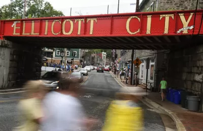
Ellicott City, Maryland, a suburb located 12-miles from Baltimore with a historic Main Street that has experienced catastrophic flooding twice since 2016, offers a case study of the complementary effects of sprawl and climate change.
Two national feature stories explore the sage of Ellicott City, a Maryland suburb that has on several occasions been made into a poster child for the need to prepare for climate change, extreme weather, and the failures of past planning.
Rebecca Hersher and Ryan Kellman report for an interactive feature, published by NPR, with testimonials, maps, and harrowing videos of stormwaters repeatedly flooding down the city's historic Main Street, destroying property and taking lives.
After floods in 2016 and 2018, county officials decided to create a new stormwater plan that would require removing ten buildings on Main Street to make room for floodwaters.
"The original plan, calling for 10 buildings to be removed, would reduce the water level to about 5 feet if a similar flood happened again," according to the article. Eight feet of water had flooded Main Street in 2016.
The idea brought serious blowback on social media and in the town, and the city went back to the drawing board.
"On May 13, 2019, the county announced the final flood plan for Old Ellicott City. It will spend at least $113 million to tear down four buildings on lower Main Street and bore one tunnel," report Hesher and Kellman.
In a separate article by Amy Plitt, published by Curbed, the story focuses a little more on the flooding as a consequence of sprawl and climate change.
First, there's the effect of sprawl in the mix of factors that created the terrible scenes on Main Street in Ellicott City in 2016 and again in 2018:
The historic center of Ellicott City was clobbered, in part, because of the suburban developments that sprung up around the town after 1960. Farmland and forests were replaced with housing, driveways, and big-box shopping centers with hundreds of parking spaces, creating geographical conditions that exacerbate the impacts of weather events like severe storms. That suburban sprawl is, on a larger scale, contributing to climate change—and there are some who think Ellicott City needs to do more to curb it.
Then there's a fact that is also true of many other cities in the United States: there's just more rain.
According to the National Climate Assessment, 'heavy rainfall events have increased' in the Northeast—which the assessment defines as the area spanning from Maryland to Maine—more than in any other region in the country. "The amount of rain that falls during these events increased by 70 percent between 1958 and 2010."
FULL STORY: After the Water

Maryland's Floods a Terrible Tragedy, and a Sign of More to Come
The sprawling, asphalt communities of U.S. cities, built as a result of mid-20th century planning, will meet terrible consequences during the extreme weather events of climate change.

A Natural Approach to Stormwater Proposed in Michigan
The realities of climate change have been on full display in Michigan this summer, and a crusading drain commissioner is pushing for stormwater infrastructure that uses natural features to capture and reuse water during extreme weather.
'Zoning for Coastal Flood Resiliency' Wins Planning Commission Approval in NYC
Emergency responses to Hurricane Sandy have turned into long-term lessons in New York City, as the nation's largest city crafts a response to sea-level rise and extreme weather by making changes to the zoning code of coastal areas.

Maui's Vacation Rental Debate Turns Ugly
Verbal attacks, misinformation campaigns and fistfights plague a high-stakes debate to convert thousands of vacation rentals into long-term housing.

Planetizen Federal Action Tracker
A weekly monitor of how Trump’s orders and actions are impacting planners and planning in America.

In Urban Planning, AI Prompting Could be the New Design Thinking
Creativity has long been key to great urban design. What if we see AI as our new creative partner?

King County Supportive Housing Program Offers Hope for Unhoused Residents
The county is taking a ‘Housing First’ approach that prioritizes getting people into housing, then offering wraparound supportive services.

Researchers Use AI to Get Clearer Picture of US Housing
Analysts are using artificial intelligence to supercharge their research by allowing them to comb through data faster. Though these AI tools can be error prone, they save time and housing researchers are optimistic about the future.

Making Shared Micromobility More Inclusive
Cities and shared mobility system operators can do more to include people with disabilities in planning and operations, per a new report.
Urban Design for Planners 1: Software Tools
This six-course series explores essential urban design concepts using open source software and equips planners with the tools they need to participate fully in the urban design process.
Planning for Universal Design
Learn the tools for implementing Universal Design in planning regulations.
planning NEXT
Appalachian Highlands Housing Partners
Mpact (founded as Rail~Volution)
City of Camden Redevelopment Agency
City of Astoria
City of Portland
City of Laramie