


A coalition of researchers have identified one area near the 101 and other near I-15 that would help keep the big cats alive and healthy.
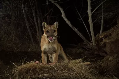
The plight of the Los Angeles mountain lion—living in a tangle of freeways—has, in recent years, been a topic of conversation often enough that a single crossing of the 101 makes the papers.
It’s also earned the attention of enough researchers that the National Park Service can now draw elaborate family trees—recently reproduced in the L.A. Times—that demonstrate how often they are hit by cars, and how the divided population has turned to inbreeding.
Fundraising was already underway, but a recent report from UC Davis, the National Park Service and the Nature Conservancy has identified two places for wildlife bridges that would accommodate the lions without drawing them too close to populated areas: one in Agoura Hills and another in Temecula. (It’s worth noting that mountain lions actively avoid humans whenever possible.)
The threat to biodiversity posed by urban sprawl has become a more frequent topic of conversation in the last decade, and there are now wildlife crossings around the world for everything from koalas to red crabs to salamanders.
FULL STORY: Mountain lions are being killed on freeways and weakened by inbreeding. Researchers have a solution

L.A. Wildlife Crossing To Break Ground This Spring
The planned wildlife bridge spanning an eight-lane freeway will be the world's largest and most ambitious project of its kind.

Study Reveals Los Angeles a Hotspot for Insect Diversity
A study reveals that L.A. is a surprising hotspot for insect and spider biodiversity, with diversity driven more by proximity to mountains and stable temperatures than by land value.

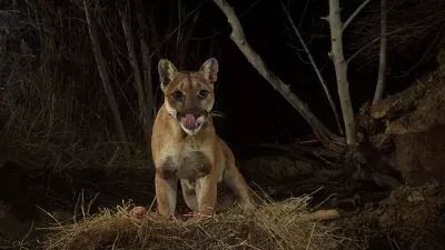
Cougar Death Highlights Urgent Need for Wildlife Crossing
A mountain lion was found dead on the 101 Freeway, less than half a mile from the steel and concrete endoskeleton of the Wallis Annenberg Wildlife Crossing.

Maui's Vacation Rental Debate Turns Ugly
Verbal attacks, misinformation campaigns and fistfights plague a high-stakes debate to convert thousands of vacation rentals into long-term housing.

Planetizen Federal Action Tracker
A weekly monitor of how Trump’s orders and actions are impacting planners and planning in America.

In Urban Planning, AI Prompting Could be the New Design Thinking
Creativity has long been key to great urban design. What if we see AI as our new creative partner?

King County Supportive Housing Program Offers Hope for Unhoused Residents
The county is taking a ‘Housing First’ approach that prioritizes getting people into housing, then offering wraparound supportive services.

Researchers Use AI to Get Clearer Picture of US Housing
Analysts are using artificial intelligence to supercharge their research by allowing them to comb through data faster. Though these AI tools can be error prone, they save time and housing researchers are optimistic about the future.

Making Shared Micromobility More Inclusive
Cities and shared mobility system operators can do more to include people with disabilities in planning and operations, per a new report.
Urban Design for Planners 1: Software Tools
This six-course series explores essential urban design concepts using open source software and equips planners with the tools they need to participate fully in the urban design process.
Planning for Universal Design
Learn the tools for implementing Universal Design in planning regulations.
planning NEXT
Appalachian Highlands Housing Partners
Mpact (founded as Rail~Volution)
City of Camden Redevelopment Agency
City of Astoria
City of Portland
City of Laramie