


While popular and common in other countries, the "Barnes Dance" crosswalk is sill catching on in the United States. Montgomery County, Maryland is the latest to test out the "All Direction" crosswalk.

A press release from the Montgomery County Government announced a big change implemented by the Montgomery County Department of Transportation (MCDOT).
The press release announces a change to the intersection at Arlington Road and Bethesda Avenue in Bethesda. MCDOT changed the traffic signals to block vehicular traffic in all directions, "allowing pedestrians to cross all legs of the intersection at the same time."
According to the press release, the all-direction crosswalk is a component of a larger safety plan for the Arlington Road corridor. "Last fall, MCDOT restriped all the crosswalks and made other repairs to improve pedestrian infrastructure on Arlington Road. Since then, traffic signals at Moorland and Edgemoor Lanes were modified to increase walk time and include leading pedestrian intervals (LPI), which provide the walk signal to pedestrians prior to the green signal for traffic in the same direction."
"All Direction" crosswalks, also known colloquially as "Barnes Dance" and "Pedestrian Scramble" crosswalks, have already gained popularity in nearby Washington, D.C. Los Angeles has also adopted a few Pedestrian Scrambles at intersections around the city.

Increased Service, Employer Tax Breaks Entice Transit Ridership in Montgomery County
Montgomery County, Maryland transit planners are hoping workers returning to the office in 2023 will rediscover the benefits of a public transit commute.
Connecting Maryland and Virginia By Transit
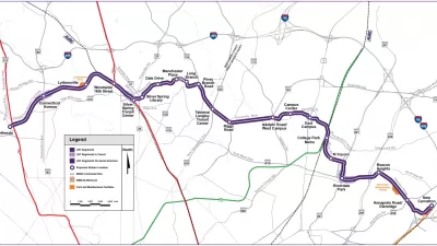
Bethesda and Tysons, in Montgomery County, Maryland, and Fairfax County, Virginia, respectively, look like neighbors on a map, but they lack a direct transit route. That could change.
Maryland's Purple Line Clears Final Legal Obstacle
A third lawsuit tried to halt the Purple Line light rail project in Maryland, but it was just the latest lawsuit to get tossed by a judge.

Planetizen Federal Action Tracker
A weekly monitor of how Trump’s orders and actions are impacting planners and planning in America.

Map: Where Senate Republicans Want to Sell Your Public Lands
For public land advocates, the Senate Republicans’ proposal to sell millions of acres of public land in the West is “the biggest fight of their careers.”

Restaurant Patios Were a Pandemic Win — Why Were They so Hard to Keep?
Social distancing requirements and changes in travel patterns prompted cities to pilot new uses for street and sidewalk space. Then it got complicated.

Platform Pilsner: Vancouver Transit Agency Releases... a Beer?
TransLink will receive a portion of every sale of the four-pack.

Toronto Weighs Cheaper Transit, Parking Hikes for Major Events
Special event rates would take effect during large festivals, sports games and concerts to ‘discourage driving, manage congestion and free up space for transit.”

Berlin to Consider Car-Free Zone Larger Than Manhattan
The area bound by the 22-mile Ringbahn would still allow 12 uses of a private automobile per year per person, and several other exemptions.
Urban Design for Planners 1: Software Tools
This six-course series explores essential urban design concepts using open source software and equips planners with the tools they need to participate fully in the urban design process.
Planning for Universal Design
Learn the tools for implementing Universal Design in planning regulations.
Heyer Gruel & Associates PA
JM Goldson LLC
Custer County Colorado
City of Camden Redevelopment Agency
City of Astoria
Transportation Research & Education Center (TREC) at Portland State University
Camden Redevelopment Agency
City of Claremont
Municipality of Princeton (NJ)