


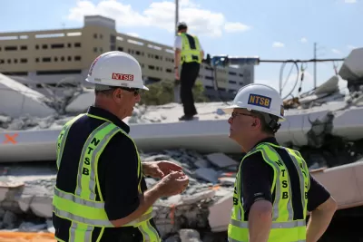
The National Transportation Safety Board is looking for the cause of the horrific collapse of the Florida International University pedestrian bridge collapse on March 15, killing six. people. Angie Schmitt questions why a ped span was needed at all.
The 850-ton steel and concrete span was the centerpiece of the FIU-City of Sweetwater UniversityCity Bridge project, spanning the eight lanes of Tamiami Trail (said to be a contraction of the phrase "Tampa to Miami") connecting Florida International University in University Park to Sweetwater where over 4,000 FIU students live.
Last August, FIU freshman Alexis Dale, was crossing the roadway, known locally as Southwest Eighth Street, when she was fatally hit by a motor vehicle. That tragic incident spurred the need for a pedestrian bridge, reports ABC News.
"You can expect most coverage to treat the [bridge collapse] as a story about construction failure," writes Angie Schmitt for Streetsblog USA on Friday, the day after the tragic collapse. "But the situation begs reporters to step back and consider a broader perspective."
Indeed, Planetizen coverage (posted Sunday) highlighted the use of accelerated bridge construction (ABC) techniques, what the Miami Herald called "instant bridge," with cranes dropping the span into place on Saturday, March 10. Media coverage now centers on the discovery of a crack in the structure, and why traffic on the busy thoroughfare wasn't halted while engineers were undergoing stress testing and cable tightening.
Why no alternative to bridge construction?
Did the process to apply for federal funding require that an alternatives analysis be performed? The $14.2 million bridge, connecting plazas and walkways is part of a $19.4 million Transportation Investment Generating Economic Recovery (TIGER) grant from the U.S. Department of Transportation, according to FIU.
"The university, the city of Miami [sic], or the state DOT [see their fact sheet (pdf) on the bridge failure] could have tried to make the whole street safer," writes Schmitt.
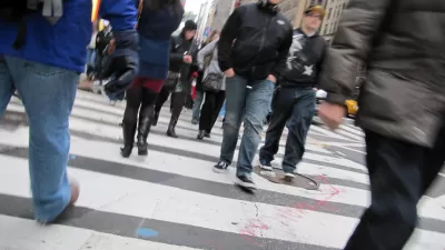
Southwest 8th Street is clearly too wide, and there are a number of ways to narrow crossing distances and reduce dangerous speeding, like adding concrete median islands, or replacing car lanes with wider sidewalks...Instead, the state of Florida chose a solution that would not disrupt the configuration for motorized traffic in any way: a pedestrian bridge.
While the bridge did indeed present a safe alternative to crossing the roadway at grade, it also "prioritized fast-moving cars," notes Schmitt, as did the ABC method. With no pedestrians crossing the street, no need for those long pedestrian count-down signals.
Separating pedestrians from motor vehicle traffic rather than integrating the two modes fits in well with the university's transportation paradigm, observes Schmitt.
The FIU campus is designed around the movement and storage of cars and is dominated by parking [jpg]. Locals tell us that there is really no transit access to the university except for a couple of out-of-the-way bus stops.
In 2015, the Miami-Dade Metropolitan Planning Organization released a study [pdf] of the 8th Street corridor. Though it mentioned the FIU campus, the report focuses almost exclusively on speeding up car traffic, not pedestrian safety. The planning agency rejected the addition of bus lanes and instead elected to make the road more like a highway, with grade separations at two intersections.
Schmitt concludes by writing that "[a]n effective approach to traffic safety would consider the dangerous conditions for pedestrians that led to the construction of the bridge in the first place. If we don’t think critically about these systemic risks, our transportation networks will keep on failing at public safety."
As of Sunday, the death toll stands at six. All victims have been recovered.
Hat tip to Len Conly via Sierra Club transportation forum.
FULL STORY: The Florida International Bridge Collapse Is About So Much More Than a Failed Structure

New Pedestrian Bridge in Miami Collapses on Thursday, Killing at Least Six
A span built to remove the danger of crossing a busy eight-lane roadway to Florida International University became the danger itself when it collapsed five days after being dropped into place using innovative bridge-building techniques.
Why Pedestrian Deaths Are Rising
Jarrett Walker offers insights into "Right of Way," a book written last year by Angie Schmitt that is influencing the traffic safety conversation and pushing the fields of planning and engineering in new directions.
Pedestrian Safety Experts: Decriminalize Jaywalking
Angie Schmitt and Charles T. Brown make nine arguments against the criminalization of jaywalking.

Planetizen Federal Action Tracker
A weekly monitor of how Trump’s orders and actions are impacting planners and planning in America.

Restaurant Patios Were a Pandemic Win — Why Were They so Hard to Keep?
Social distancing requirements and changes in travel patterns prompted cities to pilot new uses for street and sidewalk space. Then it got complicated.

Map: Where Senate Republicans Want to Sell Your Public Lands
For public land advocates, the Senate Republicans’ proposal to sell millions of acres of public land in the West is “the biggest fight of their careers.”

Maui's Vacation Rental Debate Turns Ugly
Verbal attacks, misinformation campaigns and fistfights plague a high-stakes debate to convert thousands of vacation rentals into long-term housing.

San Francisco Suspends Traffic Calming Amidst Record Deaths
Citing “a challenging fiscal landscape,” the city will cease the program on the heels of 42 traffic deaths, including 24 pedestrians.

California Homeless Arrests, Citations Spike After Ruling
An investigation reveals that anti-homeless actions increased up to 500% after Grants Pass v. Johnson — even in cities claiming no policy change.
Urban Design for Planners 1: Software Tools
This six-course series explores essential urban design concepts using open source software and equips planners with the tools they need to participate fully in the urban design process.
Planning for Universal Design
Learn the tools for implementing Universal Design in planning regulations.
Heyer Gruel & Associates PA
JM Goldson LLC
Custer County Colorado
City of Camden Redevelopment Agency
City of Astoria
Transportation Research & Education Center (TREC) at Portland State University
Camden Redevelopment Agency
City of Claremont
Municipality of Princeton (NJ)