


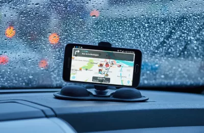
For the second time at the same railroad crossing in Atherton, California, a motorist followed his GPS navigation onto Caltrain tracks. In both cases, the motorists fled their vehicles before being hit by an oncoming train.
The car hit Saturday night was a classic, 1950s-era Autin-Healey, identifiable by its grill, about the only recognizable part remaining after being dragged about a quarter-mile by a southbound Caltrain baby bullet. The crash occurred shortly after Caltrain #804 left the Redwood City station at 8:07 pm, heading for its next stop, Palo Alto.
"After extinguishing the vehicle fire, Menlo Park firefighters were able to free what was left of the classic car by 10:26 p.m. using the jaws of life and other extrication equipment to (release) the twisted metal and debris from under the much larger locomotive,” the fire district said in a statement, reports the Daily Post staff on Feb. 10.
No injuries were reported onboard the train. The 349 passengers were transferred to the next southbound about two hours later according to Adrian Brandt, who was monitoring Caltrain radio transmissions.
The San Mateo County Sheriff's Department reports "that the driver turned onto the track while using GPS and got stuck," according to NBC Bay Area.
"[Menlo Park] Fire Chief Harold Schapelhouman said this is the second car that has been stuck at this crossing and caught fire," adds the Post.
“The last time this occurred in December of 2014, a driver following his navigation system on a dark and rainy night turned onto the tracks and the vehicle became stuck. Fortunately, in both of these cases, the drivers were able to escape from their vehicles before being struck by a southbound passenger train,” Schapelhouman said.
Last October, a similar, GPS navigation-caused crash occurred at a Caltrain crossing in Palo Alto, just a few miles south. Fortunately, the driver and his passengers abandoned the rental car and no passengers or crew were injured on the train.
Special Four Quad Gates Irrelevant
The scene of Saturday's crash, the Fair Oaks Lane crossing adjacent to the Atherton station, open only weekends but not served by express trains, is also the first and only "quiet zone" on the San Francisco-to-San Jose Caltrain line, the nation's third busiest commuter rail line when measured by ridership per mile.
Extra safety precautions must be installed at these locations that don't require locomotives to routinely blast their horns, such as four-quadrant gates which have proven very effective in preventing crashes caused by motorists attempting to "beat the train" by driving around conventional two-quad gates. However, their application is limited to when the gates have been engaged, i.e., before a train approaches.
An "Analysis of Safety at Quiet Zones" [pdf] released by the Federal Rail Administration (FRA) in 2014 found "[n]o significant difference in collisions before and after the establishment of quiet zones."
Not an anomaly
GPS navigation-related incidents at rail crossings occur more frequently than one might imagine, although the FRA doesn't quantify them. In 2016, 2,025 highway-rail crossing collisions occurred, resulting in 265 fatalities, according to the FRA. One of the more deadly ones, and the first to officially be linked to GPS, occurred in February 2015 after a truck drove onto Metrolink tracks in Oxnard, Calif. The resulting crash derailed the train, killing the engineer, who was operating the train in the front cab car.
"What made this crash stand out was the possible role of digital mapping technology in taking a driver down a wrong path," reported Daisuke Wakabayashi for The New York Times on Dec. 19, 2016. "This was the first time the [National Transportation Safety Board] has targeted navigation apps as a factor in a major accident."
Audio warning?
Reporting for the Hartford Courant on a more deadly train crash, also is February 2015 but at a Metro-North grade crossing in Valhalla, N.Y. that was not linked to the motorist using a navigation app, Don Stacom wrote in March, 2016 that "[s]ome analysts have suggested that vehicle navigation systems play a role in crashes, because drivers follow the GPS directions but don't get an audio warning that they're approaching railroad tracks.
The FRA last spring reached an agreement with Google to have rail crossing information used in its navigation systems, and the agency is trying to get Garmin and other GPS producers to do likewise."
Hat tip to Adrian Brandt.
FULL STORY: Caltrain hits classic car, drags it a quarter mile


Maui's Vacation Rental Debate Turns Ugly
Verbal attacks, misinformation campaigns and fistfights plague a high-stakes debate to convert thousands of vacation rentals into long-term housing.

Planetizen Federal Action Tracker
A weekly monitor of how Trump’s orders and actions are impacting planners and planning in America.

Chicago’s Ghost Rails
Just beneath the surface of the modern city lie the remnants of its expansive early 20th-century streetcar system.

Bend, Oregon Zoning Reforms Prioritize Small-Scale Housing
The city altered its zoning code to allow multi-family housing and eliminated parking mandates citywide.

Amtrak Cutting Jobs, Funding to High-Speed Rail
The agency plans to cut 10 percent of its workforce and has confirmed it will not fund new high-speed rail projects.

LA Denies Basic Services to Unhoused Residents
The city has repeatedly failed to respond to requests for trash pickup at encampment sites, and eliminated a program that provided mobile showers and toilets.
Urban Design for Planners 1: Software Tools
This six-course series explores essential urban design concepts using open source software and equips planners with the tools they need to participate fully in the urban design process.
Planning for Universal Design
Learn the tools for implementing Universal Design in planning regulations.
planning NEXT
Appalachian Highlands Housing Partners
Mpact (founded as Rail~Volution)
City of Camden Redevelopment Agency
City of Astoria
City of Portland
City of Laramie