


San Francisco could become the first U.S. city to use demand-based parking rates citywide.
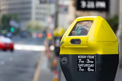
"Surge pricing could be coming to every parking meter in San Francisco in 2018 under a plan being considered by the Municipal Transportation Agency," reports Michael Cabanatuan.
The city already uses dynamic pricing for 7,000 parking spaces around the city, after its pioneering SFPark pilot program to test the concept concluded in 2014. After the pilot concluded, the MTA continued demand-based pricing "in some of the city’s busiest neighborhoods — downtown, South of Market, the Mission, the Embarcadero, Fisherman’s Wharf, Mission Bay, the Fillmore and the Marina," according to Cabanatuan. If the MTA approves the proposal to extend demand-based dynamic pricing citywide, it would be the first time the concept has been in implemented in more residential neighborhoods.
Cabanatuan also describes the reasoning by the demand-based pricing concept, which will be familiar to anyone who has read Donald Shoup's The High Cost of Free Parking:
MTA officials say the approach is intended to increase the availability of coveted city parking spaces, particularly in areas where demand is high. People unwilling to pay the higher rates might seek parking farther away, remain for a shorter period of time, or leave their car at home.
FULL STORY: SF set to become first US city to price all metered parking based on demand


Maui's Vacation Rental Debate Turns Ugly
Verbal attacks, misinformation campaigns and fistfights plague a high-stakes debate to convert thousands of vacation rentals into long-term housing.

Planetizen Federal Action Tracker
A weekly monitor of how Trump’s orders and actions are impacting planners and planning in America.

San Francisco Suspends Traffic Calming Amidst Record Deaths
Citing “a challenging fiscal landscape,” the city will cease the program on the heels of 42 traffic deaths, including 24 pedestrians.

Defunct Pittsburgh Power Plant to Become Residential Tower
A decommissioned steam heat plant will be redeveloped into almost 100 affordable housing units.

Trump Prompts Restructuring of Transportation Research Board in “Unprecedented Overreach”
The TRB has eliminated more than half of its committees including those focused on climate, equity, and cities.

Amtrak Rolls Out New Orleans to Alabama “Mardi Gras” Train
The new service will operate morning and evening departures between Mobile and New Orleans.
Urban Design for Planners 1: Software Tools
This six-course series explores essential urban design concepts using open source software and equips planners with the tools they need to participate fully in the urban design process.
Planning for Universal Design
Learn the tools for implementing Universal Design in planning regulations.
Heyer Gruel & Associates PA
JM Goldson LLC
Custer County Colorado
City of Camden Redevelopment Agency
City of Astoria
Transportation Research & Education Center (TREC) at Portland State University
Jefferson Parish Government
Camden Redevelopment Agency
City of Claremont