


The Pacific Northwest's competing and sometimes conflicting stakeholders have created a master plan for the use—and also the preservation—of marine resources.
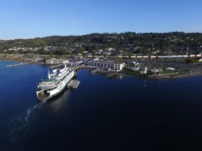
On October 12, the Department of Ecology in Washington State released a document it has named the Draft Marine Spatial Plan for Washington’s Pacific Coast.
That somewhat uninventive title is a disservice to what Washington has actually done—created a collaborative master plan using the increasingly popular process called Marine Spatial Planning.
Marine Spatial Planning (MSP) aims, more or less, to take the basic tenets of modern land-use planning—engaging many stakeholders, considering commercial, social and environmental trade-offs—and establishing comprehensive plans for marine areas.
Massachusetts and Rhode Island have employed MSP for ocean-resource master plans, and the process is underway in San Diego; Marine Spatial Planning is also in use for various projects around the nation and the world, particularly in places most affected by climate change. In Washington, observers hope the process can dampen longstanding conflicts between interests, and provide "a framework to guide decisions about new development on the outer coast."
The Draft Marine Spatial Plan for Washington's Pacific Coast is now open to public comment.
FULL STORY: HOW WILL WASHINGTON’S COAST DEVELOP?


Op-Ed: Why NYC Needs a Comprehensive Plan
The city’s congestion pricing program could change transportation and land use in radical ways. A comprehensive plan would make the most of those changes.

Controversial Comprehensive Plan Update Moves Forward in Charlottesville
Residents have had a chance to oppose the new residential density proposed by the "Charlottesville Plans Together" comprehensive planning process.
New York City Aims for Comprehensive Long-Range Planning
The city's proposed comprehensive planning bill could create a more equitable and collaborative planning process

Planetizen Federal Action Tracker
A weekly monitor of how Trump’s orders and actions are impacting planners and planning in America.

San Francisco's School District Spent $105M To Build Affordable Housing for Teachers — And That's Just the Beginning
SFUSD joins a growing list of school districts using their land holdings to address housing affordability challenges faced by their own employees.

The Tiny, Adorable $7,000 Car Turning Japan Onto EVs
The single seat Mibot charges from a regular plug as quickly as an iPad, and is about half the price of an average EV.

As Trump Phases Out FEMA, Is It Time to Flee the Floodplains?
With less federal funding available for disaster relief efforts, the need to relocate at-risk communities is more urgent than ever.

With Protected Lanes, 460% More People Commute by Bike
For those needing more ammo, more data proving what we already knew is here.

In More Metros Than You’d Think, Suburbs are Now More Expensive Than the City
If you're moving to the burbs to save on square footage, data shows you should think again.
Urban Design for Planners 1: Software Tools
This six-course series explores essential urban design concepts using open source software and equips planners with the tools they need to participate fully in the urban design process.
Planning for Universal Design
Learn the tools for implementing Universal Design in planning regulations.
Smith Gee Studio
City of Charlotte
City of Camden Redevelopment Agency
City of Astoria
Transportation Research & Education Center (TREC) at Portland State University
US High Speed Rail Association
City of Camden Redevelopment Agency
Municipality of Princeton (NJ)