


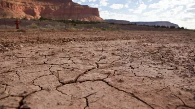
Climate change is only part of the story, but humans have left a detectable footprint on the distribution of the global water supply.

Eric Holthaus shares news of a new study that analyzes data from groundwater-detecting satellites. The results of the study, published in the journal Nature, are "equal parts terrifying and long-expected," according to Holthaus.
The authors used the satellite data to construct a map of 34 rapidly changing regions around the world, painting a unified picture of current hot spots of water scarcity and excess. Nearly every activity that involves people requires water — rice farming, nuclear power, aluminum smelting, you name it — so the lives of people living where reserves are being rapidly depleted are under grave threat.
According to Holthaus, the study makes the future threat of water scarcity abundantly clear.
FULL STORY: We can now see how humans have altered Earth’s water resources

Researchers Propose the Concept of 'Anthropogenic Drought'
As climate change heightens the risk of intense drought periods, a new framework can help scientists better understand the interconnected causes and effects of drought.

Southern California's Water Conservation and Storage Efforts Paying Off
The region has poured over a billion dollars into storage infrastructure and demand management policies in anticipation of worsening drought conditions.

Drought Contingency Plan Triggered for the Colorado River
Signs of worsening drought conditions in the American West are triggering early actions for states that depend on water from the Colorado River.

Planetizen Federal Action Tracker
A weekly monitor of how Trump’s orders and actions are impacting planners and planning in America.

San Francisco's School District Spent $105M To Build Affordable Housing for Teachers — And That's Just the Beginning
SFUSD joins a growing list of school districts using their land holdings to address housing affordability challenges faced by their own employees.

The Tiny, Adorable $7,000 Car Turning Japan Onto EVs
The single seat Mibot charges from a regular plug as quickly as an iPad, and is about half the price of an average EV.

San Diego Votes to Rein in “Towering” ADUs
City council voted to limit the number of units in accessory buildings to six — after confronting backyard developments of up to 100 units behind a single family home.

Texas Legislature’s Surprising Pro-Housing Swing
Smaller homes on smaller lots, office to apartment conversions, and 40% less say for NIMBYs, vote state lawmakers.

Even Edmonton Wants Single Staircase Buildings
Canada's second most affordable major city joins those angling to nix the requirement for two staircases in multi-family buildings.
Urban Design for Planners 1: Software Tools
This six-course series explores essential urban design concepts using open source software and equips planners with the tools they need to participate fully in the urban design process.
Planning for Universal Design
Learn the tools for implementing Universal Design in planning regulations.
Borough of Carlisle
Smith Gee Studio
City of Camden Redevelopment Agency
City of Astoria
Transportation Research & Education Center (TREC) at Portland State University
City of Camden Redevelopment Agency
Municipality of Princeton (NJ)