


An oversight committee has approved the Locally Preferred Alternative for the Review Corridor Streetcar project that will connect Downtown St. Paul to the Minneapolis-St. Paul International Airport.
Peter Callaghan reports on the status of the proposed streetcar line between St. Paul and the Minneapolis-St. Paul International Airport, otherwise known as the Riverview Corridor.
The Riverview Corridor Policy Advisory Committee approved a preferred route for the light rail line—leaving downtown via West 7th Street, crossing the Mississippi River, and joining the Blue Line at the Fort Snelling station.
Despite the committee's vote, however, Callaghan reports that it will be six years at least before the project could be complete and open to the public. Callaghan's coverage includes more details about the steps that will have to be taken to deliver the project, as well as some of the delays that have already obstructed progress for the project that was once intended to be the first region's first new light rail corridor. Now it will be the fifth, "behind even the Southwest LRT extension of the Green Line and the Bottineau extension of the Blue Line," according to Callaghan.
FULL STORY: The Riverview Corridor just reached a big milestone. So why doesn't it feel that way?

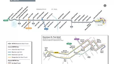
New Bus Rapid Transit Route Breaks Ground in the Twin Cities
The Twin Cities are on a mission to become the bus rapid transit capital of the United States. The latest improvement to advance that ambition broke ground earlier this week.

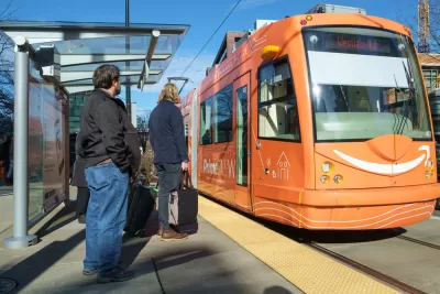
Twin Cities Trains Move to Fewer Cars, Higher Frequency
Headways will drop from 15 minutes to 12 minutes.
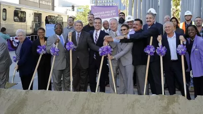
Tardy Transit Funding Arrives in Los Angeles, Twin Cities
They had to wait the better part of a year, but two major transit projects finally have the funding Congress allocated in March.

Planetizen Federal Action Tracker
A weekly monitor of how Trump’s orders and actions are impacting planners and planning in America.

Chicago’s Ghost Rails
Just beneath the surface of the modern city lie the remnants of its expansive early 20th-century streetcar system.

San Antonio and Austin are Fusing Into one Massive Megaregion
The region spanning the two central Texas cities is growing fast, posing challenges for local infrastructure and water supplies.

Since Zion's Shuttles Went Electric “The Smog is Gone”
Visitors to Zion National Park can enjoy the canyon via the nation’s first fully electric park shuttle system.

Trump Distributing DOT Safety Funds at 1/10 Rate of Biden
Funds for Safe Streets and other transportation safety and equity programs are being held up by administrative reviews and conflicts with the Trump administration’s priorities.

German Cities Subsidize Taxis for Women Amid Wave of Violence
Free or low-cost taxi rides can help women navigate cities more safely, but critics say the programs don't address the root causes of violence against women.
Urban Design for Planners 1: Software Tools
This six-course series explores essential urban design concepts using open source software and equips planners with the tools they need to participate fully in the urban design process.
Planning for Universal Design
Learn the tools for implementing Universal Design in planning regulations.
planning NEXT
Appalachian Highlands Housing Partners
Mpact (founded as Rail~Volution)
City of Camden Redevelopment Agency
City of Astoria
City of Portland
City of Laramie