


Some of the San Francisco neighborhoods with the worst air quality are also the San Francisco neighborhoods with the most development.
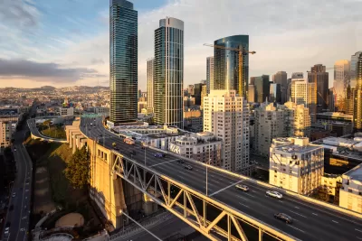
"The most recent figures available from the Bay Area Air Quality Management District — a map based on 2010 data — show that air pollution runs along the city’s highways, and Interstate 80 cuts straight through SoMa, South Park, South Beach and the city’s new high-rise neighborhood, Rincon Hill," reports Rachel Swan.
Swan cites neighborhood representatives who tie the worsening air pollution to worsening congestion as the city grows in population and employment. Multiple data sources also show that congestion is worsening in the city.
With more projects on the way in these neighborhoods, like the Warriors’ Chase Arena in Mission Bay and the California Pacific Medical Center on Van Ness Avenue, air pollution, connected to congestion, has obviously become another talking point for development opponents.
San Francisco is taking some steps to mitigate the existing air pollution. Swan summarizes:
In 2008, San Francisco enacted a law requiring ventilation systems and filters in new residential buildings, child care centers and private schools, which affected a lot of the projects being built South of Market. And in 2015, it mandated that contractors use cleaner equipment in the city’s most polluted areas, which also include parts of the Bayview, isolated areas around Fisherman’s Wharf and along Highway 101 through Potrero Hill and Visitacion Valley.
Public health officials are also currently working on a draft Community Risk Reduction Plan.
FULL STORY: Map shows which SF neighborhoods are hit hardest by air pollution

San Francisco ‘Best-Performing Metro’ for VMT, Traffic Reduction
The city saw a 13 percent drop in miles driven per capita in the last five years.
More Cities Ponder the End of Drive-Thrus
Drive-thru fast food restaurants might be a staple of American life, but several U.S. cities are actively considering prohibiting the development of new drive-thrus for the benefit of traffic safety, air quality, and congestion.
Study: More Bike Infrastructure Could Prevent 15,000 Deaths Annually
In addition to reducing air pollution and congestion, improving bike infrastructure could save thousands of lives each year, according to new research.

Planetizen Federal Action Tracker
A weekly monitor of how Trump’s orders and actions are impacting planners and planning in America.

San Francisco's School District Spent $105M To Build Affordable Housing for Teachers — And That's Just the Beginning
SFUSD joins a growing list of school districts using their land holdings to address housing affordability challenges faced by their own employees.

Can We Please Give Communities the Design They Deserve?
Often an afterthought, graphic design impacts everything from how we navigate a city to how we feel about it. One designer argues: the people deserve better.

The EV “Charging Divide” Plaguing Rural America
With “the deck stacked” against rural areas, will the great electric American road trip ever be a reality?

Judge Halts Brooklyn Bike Lane Removal
Lawyers must prove the city was not acting “arbitrarily, capriciously, and illegally” in ordering the hasty removal.

Engineers Gave America's Roads an Almost Failing Grade — Why Aren't We Fixing Them?
With over a trillion dollars spent on roads that are still falling apart, advocates propose a new “fix it first” framework.
Urban Design for Planners 1: Software Tools
This six-course series explores essential urban design concepts using open source software and equips planners with the tools they need to participate fully in the urban design process.
Planning for Universal Design
Learn the tools for implementing Universal Design in planning regulations.
Borough of Carlisle
Smith Gee Studio
City of Camden Redevelopment Agency
City of Astoria
Transportation Research & Education Center (TREC) at Portland State University
City of Camden Redevelopment Agency
Municipality of Princeton (NJ)