


Parting shots from the Great American Eclipse.
"The Great American Eclipse has, as expected, turned into the Great American Traffic Snarl," according to an article by Douglas Perry. The proof is in the Google Maps: Perry posts a series of screengrabs to show the long red lines where traffic slowed to a standstill as the eclipse moved across the path of totality yesterday. First congestion came to Western Oregon, and then Eastern Oregon, and then Idaho and Wyoming, and so on.
For a perhaps more awe-inducing view of the eclipse, and maybe to wash the image of all that traffic from your mind, here's satellite imagery from GOES-16, showing the darkness of the eclipse moving across the continent.
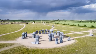
And as one last testament to the power of collective human reaction to the unfathomable scale of nature, we present the story of Carhenge, as detailed in an article by Bart Schaneman. "When Jim Reinders built Carhenge — a Stonehenge replica made out of classic American cars — it was decades before anyone was talking about the path of totality," according to Schaneman. The project was viewed with skepticism in Nebraska, where Carhenge was built, until the it became "one of the most talked-about destinations to view the eclipse in the entire country." It turns out, however, that Reinders never anticipated the Great American Eclipse.
FULL STORY: Epic traffic snarls follow 2017 eclipse totality path, Google Maps shows

How People Will See the Eclipse Today
A 33-year GIS professional lets loose his geospatial and population analysis skills on the occasion of a lifetime: today's "Great American Eclipse."

Judge Extends NYC Congestion Pricing Through at Least June 9
A federal judge halted the Trump administration’s effort to kill the program, which remains in limbo as a lawsuit filed by the MTA moves forward.

NYC Congestion Pricing Continues to Show Positive Results
While the Trump administration attempts to revoke the program’s federal approval, congestion pricing continues to reduce traffic, speed up bus travel times, and improve air quality in Manhattan.

Planetizen Federal Action Tracker
A weekly monitor of how Trump’s orders and actions are impacting planners and planning in America.

Map: Where Senate Republicans Want to Sell Your Public Lands
For public land advocates, the Senate Republicans’ proposal to sell millions of acres of public land in the West is “the biggest fight of their careers.”

Restaurant Patios Were a Pandemic Win — Why Were They so Hard to Keep?
Social distancing requirements and changes in travel patterns prompted cities to pilot new uses for street and sidewalk space. Then it got complicated.

Platform Pilsner: Vancouver Transit Agency Releases... a Beer?
TransLink will receive a portion of every sale of the four-pack.

Toronto Weighs Cheaper Transit, Parking Hikes for Major Events
Special event rates would take effect during large festivals, sports games and concerts to ‘discourage driving, manage congestion and free up space for transit.”

Berlin to Consider Car-Free Zone Larger Than Manhattan
The area bound by the 22-mile Ringbahn would still allow 12 uses of a private automobile per year per person, and several other exemptions.
Urban Design for Planners 1: Software Tools
This six-course series explores essential urban design concepts using open source software and equips planners with the tools they need to participate fully in the urban design process.
Planning for Universal Design
Learn the tools for implementing Universal Design in planning regulations.
Heyer Gruel & Associates PA
JM Goldson LLC
Custer County Colorado
City of Camden Redevelopment Agency
City of Astoria
Transportation Research & Education Center (TREC) at Portland State University
Camden Redevelopment Agency
City of Claremont
Municipality of Princeton (NJ)