


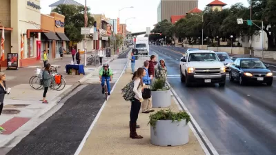
Complete streets policies are keeping planners busy across the country. An annual report features the best of the best when it comes to transforming city streets for the safety and activity of all users.

Rachel Dovey reports on the release of Smart Growth America's "Best Complete Streets Policies 2016" [pdf] report.
The report grants a three-way tie at the top of the report's ranking, with three cities achieving a perfect policy score of 100: Brockton, Massachusetts; Missoula, Montana; and Wenatchee, Washington.
Here Dovey explains more about the methodology of the report:
To assess a city’s streets, the coalition looks at resolutions, internal policies adopted by leadership, statements codified by stakeholders and tax ordinances. It measures those policies on a number of merits, including vision, design, implementation steps and the consideration of “all users and modes,” among others.
For last year's report, Kelsey E. Thomas wrote about the quick growth of complete streets policies around the country. A decade ago there were only 32 such policies in place. By 2016, there were 1,232 policies in the U.S and Puerto Rico.
Planetizen featured the release of the 2014 report and covered the 2013 report as well.
FULL STORY: Ranking Spotlights New Complete Streets Policies


Complete Streets Policies Still Seeking Equity
Though the quick expansion of complete streets policies is worth celebrating, minority and low-income communities are still being left behind, and killed at a disproportionate rate.
Celebrating the Best Complete Streets Policies of 2014
The nationwide trend of cities, counties, and regions adopting complete streets policies continued its momentum in 2014. A new report from the National Complete Streets Coalition surveys the field and decides which is the best of the best.
Safe Streets 'Champions' Announced
Smart Growth America and the National Complete Streets Coalition announced a new initiative designed to help cities achieve the potential of a new approach to street design.

Montreal Mall to Become 6,000 Housing Units
Place Versailles will be transformed into a mixed-use complex over the next 25 years.

Planetizen Federal Action Tracker
A weekly monitor of how Trump’s orders and actions are impacting planners and planning in America.

DARTSpace Platform Streamlines Dallas TOD Application Process
The Dallas transit agency hopes a shorter permitting timeline will boost transit-oriented development around rail stations.

Study: 4% of Truckers Lack a Valid Commercial License
Over 56% of inspected trucks had other violations.

Chicago Judge Orders Thousands of Accessible Ped Signals
Only 3% of the city's crossing signals are currently accessible to blind pedestrians.

Philadelphia Swaps Car Lanes for Bikeways in Unanimous Vote
The project will transform one of the handful of streets responsible for 80% of the city’s major crashes.
Urban Design for Planners 1: Software Tools
This six-course series explores essential urban design concepts using open source software and equips planners with the tools they need to participate fully in the urban design process.
Planning for Universal Design
Learn the tools for implementing Universal Design in planning regulations.
City of Mt Shasta
City of Camden Redevelopment Agency
City of Astoria
Transportation Research & Education Center (TREC) at Portland State University
US High Speed Rail Association
City of Camden Redevelopment Agency
Municipality of Princeton (NJ)