


The advent of sprawl coincided with a move toward earlier school start times, prompted by a need to coordinate complicated bussing. If students could walk to school, the problem might disappear.

It's hard to believe as a younger person, but before mass suburbanization school used to start at 9 a.m. or later. That isn't the case today. Mimi Kirk writes, "according to the Centers for Disease Control and Prevention, at least 75 percent of schools surveyed in more than 40 states for a 2015 report started before 8:30 a.m., with a significant number starting in the 7 a.m. hour."
Why the change? Kirk traces it to the 1960s and 1970s, when sprawl began to make walking to school difficult. Cultural changes around childrearing also discouraged walking. The result, a tiered bus schedule, imposed early start times for high schoolers. As driving became the norm, so did an early start.
Kirk discusses how the 7:30 a.m. start may cut into young people's sleep needs. "That research, which recently led both the CDC and the American Academy of Pediatrics to urge later start times at American schools, shows that teenagers need at least nine hours of sleep a night."
A movement to push back school start times is picking up speed, but faces its share of debate. Long-term, a common sense solution to the problem would be to re-enable walks to school. But that would require walkable communities, and encouraging those can be an uphill climb both ways.
FULL STORY: Suburban Sprawl Stole Your Kids' Sleep

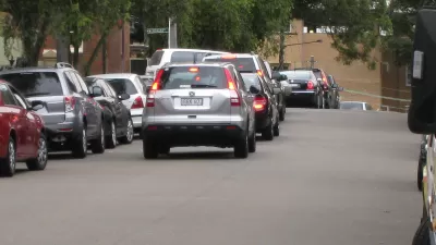
How Schools Can Address Idling Cars
Schools can do more to reduce the environmental threat posed by idling cars during drop-off or pick-up. School districts could also improve their buses with that aim in mind.

The Natalist Case For Sprawl (And Why It Fails)
Some commentators defend anti-urban government policies such as exclusionary zoning on the basis that homeowning suburbanites have high birth rates. But this doesn't seem to be true in recent decades.

Parents Turn to Ride-Hailing as Schools Pull Bus Transportation
Some districts are cutting back on school buses, leaving some children without reliable transportation to and from school.

Planetizen Federal Action Tracker
A weekly monitor of how Trump’s orders and actions are impacting planners and planning in America.

Congressman Proposes Bill to Rename DC Metro “Trump Train”
The Make Autorail Great Again Act would withhold federal funding to the system until the Washington Metropolitan Area Transit Authority (WMATA), rebrands as the Washington Metropolitan Authority for Greater Access (WMAGA).

DARTSpace Platform Streamlines Dallas TOD Application Process
The Dallas transit agency hopes a shorter permitting timeline will boost transit-oriented development around rail stations.

San Francisco's School District Spent $105M To Build Affordable Housing for Teachers — And That's Just the Beginning
SFUSD joins a growing list of school districts using their land holdings to address housing affordability challenges faced by their own employees.

Car-Centric LA Suburb Looks to a Train-Oriented Future
City leaders in Rancho Cucamonga, the future western terminus of the Brightline West rail line to Las Vegas, want to reimagine the city as a transit-oriented, pedestrian-friendly community.

New Alaska Bitcoin Mine Would Burn as Much Energy as the State’s Largest Coal Plant
Fueled by “stranded” natural gas, the startup hopes to become the largest in the US, and to make Alaska an industry center.
Urban Design for Planners 1: Software Tools
This six-course series explores essential urban design concepts using open source software and equips planners with the tools they need to participate fully in the urban design process.
Planning for Universal Design
Learn the tools for implementing Universal Design in planning regulations.
Municipality of Princeton
Roanoke Valley-Alleghany Regional Commission
City of Mt Shasta
City of Camden Redevelopment Agency
City of Astoria
Transportation Research & Education Center (TREC) at Portland State University
US High Speed Rail Association
City of Camden Redevelopment Agency
Municipality of Princeton (NJ)