


Post-recession population growth in the United States looks a lot like pre-recession growth in the United States. As some have predicted or already noticed: the story of U.S. growth is still suburban.

"Population growth in big cities slowed for the fifth-straight year in 2016," reports Jed Kolko, in an initial analysis of U.S. Census Bureau statistics released earlier today. His pronunciation to accompany the data: "The suburbanization of America marches on."
To complete his analysis, Kolko grouped each of the more than 3,000 U.S. counties into six categories: "urban centers of large metropolitan areas; their densely populated suburbs; their lightly populated suburbs; midsize metros; smaller metro areas; and rural counties, which are outside metro areas entirely."
Of these six categories, Kolko found the fastest growth in the lower-density suburbs. "Those counties grew by 1.3 percent in 2016, the fastest rate since 2008, when the housing bust put an end to rapid homebuilding in these areas."
Kolko also says what you've probably been thinking while reading those findings: "Those figures run counter to the 'urban revival' narrative that has been widely discussed in recent years."
Kolko's analysis takes closer look at the data, finding which kinds of geographic areas are growing and which are shrinking.
FULL STORY: Americans’ Shift To The Suburbs Sped Up Last Year

Population Decline in the Latest Census Estimates
Not only are suburbs growing, many of the larger, older cities that had reversed decades of population decline, are now losing population, again. The biggest losers: counties with the greatest population densities.
Population Growth Trends Return to Pre-Recession Norms
It's almost like the Great Recession and the Great Urban Renaissance never happened, as Americans are moving to the suburbs and the Sunbelt than to the nation's urban areas.
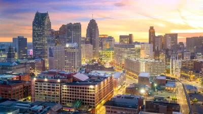
Detroit and Michigan on the Upswing
It's been 66 years since the Motor City last grew its population. Census data released last month revealed an increase of nearly 2,000 people last year, nearly half the state's population growth.

Planetizen Federal Action Tracker
A weekly monitor of how Trump’s orders and actions are impacting planners and planning in America.

Map: Where Senate Republicans Want to Sell Your Public Lands
For public land advocates, the Senate Republicans’ proposal to sell millions of acres of public land in the West is “the biggest fight of their careers.”

Restaurant Patios Were a Pandemic Win — Why Were They so Hard to Keep?
Social distancing requirements and changes in travel patterns prompted cities to pilot new uses for street and sidewalk space. Then it got complicated.

California Homeless Arrests, Citations Spike After Ruling
An investigation reveals that anti-homeless actions increased up to 500% after Grants Pass v. Johnson — even in cities claiming no policy change.

Albuquerque Route 66 Motels Become Affordable Housing
A $4 million city fund is incentivizing developers to breathe new life into derelict midcentury motels.

DC Area County Eliminates Bus Fares
Montgomery County joins a growing trend of making transit free.
Urban Design for Planners 1: Software Tools
This six-course series explores essential urban design concepts using open source software and equips planners with the tools they need to participate fully in the urban design process.
Planning for Universal Design
Learn the tools for implementing Universal Design in planning regulations.
Heyer Gruel & Associates PA
JM Goldson LLC
Custer County Colorado
City of Camden Redevelopment Agency
City of Astoria
Transportation Research & Education Center (TREC) at Portland State University
Camden Redevelopment Agency
City of Claremont
Municipality of Princeton (NJ)