


Walkability and density have been studied closely, and now their worth has been quantified and proven, according to Brent Toderian in a piece for Metro Toronto.
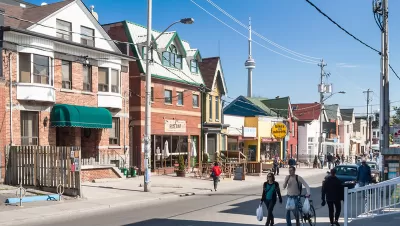
Brent Toderian argues in an editorial for Metro Toronto that many common misconceptions about planning can be dispelled with a numbers-based approach. While he concedes, with a Yogi Berra-type turn of phrase, that "Not all that counts can be counted," many assertions about the value of walkability and multimodal transit have been tested and studied and the numbers prove the worth of both.
Citing a study finding that compact development, on average, costs 38 percent less in up-front infrastructure and 10 percent less in ongoing service delivery than conventional suburban development. Compact development also generates 10 times more per acre in tax revenue, according to the study. Toderian's writing also highlights further benefits to residents and governments: "That crime goes down as density goes up. That providing housing for the homeless actually saves public money. That you can move more people on a street when car lanes are replaced by well-designed space for walking, biking and transit."
FULL STORY: Math myth-busting some of our worst urban planning misconceptions


North Texas Transit Leaders Tout Benefits of TOD for Growing Region
At a summit focused on transit-oriented development, policymakers discussed how North Texas’ expanded light rail system can serve as a tool for economic growth.

California Bill Aims to Boost TOD
A bill proposed by Sen. Scott Wiener would exempt transit agencies from zoning rules near ‘high-quality’ transit stops and allow denser transit-oriented development.

Density and Disorder: The Imaginary Link
A recent article tries to tie public transit and walkability to social disorder — but in fact, sprawling Sunbelt cities like Memphis are as likely to have high crime rates as transit-rich metropolises such as New York and San Francisco.

Planetizen Federal Action Tracker
A weekly monitor of how Trump’s orders and actions are impacting planners and planning in America.

Maui's Vacation Rental Debate Turns Ugly
Verbal attacks, misinformation campaigns and fistfights plague a high-stakes debate to convert thousands of vacation rentals into long-term housing.

Restaurant Patios Were a Pandemic Win — Why Were They so Hard to Keep?
Social distancing requirements and changes in travel patterns prompted cities to pilot new uses for street and sidewalk space. Then it got complicated.

In California Battle of Housing vs. Environment, Housing Just Won
A new state law significantly limits the power of CEQA, an environmental review law that served as a powerful tool for blocking new development.

Boulder Eliminates Parking Minimums Citywide
Officials estimate the cost of building a single underground parking space at up to $100,000.

Orange County, Florida Adopts Largest US “Sprawl Repair” Code
The ‘Orange Code’ seeks to rectify decades of sprawl-inducing, car-oriented development.
Urban Design for Planners 1: Software Tools
This six-course series explores essential urban design concepts using open source software and equips planners with the tools they need to participate fully in the urban design process.
Planning for Universal Design
Learn the tools for implementing Universal Design in planning regulations.
Heyer Gruel & Associates PA
JM Goldson LLC
Custer County Colorado
City of Camden Redevelopment Agency
City of Astoria
Transportation Research & Education Center (TREC) at Portland State University
Jefferson Parish Government
Camden Redevelopment Agency
City of Claremont