


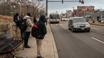
Students at Emerson College live with the frustrations of the intersection of Boylston and Tremont streets everyday. They also have ideas for how to fix the intersection.
"Every day, swarms of Boston pedestrians scurry from all four corners of the intersection at Boylston and Tremont streets, jostling in the middle of the road like concertgoers in a mosh pit at a heavy-metal concert, as they try to beat the crosswalk countdown signals before the lights turn green and cars begin to go," writes Steve Annear.
The problem described by Annear inspired a Civic Art and Design Studio at nearby Emerson College to produce a collection of proposals to improve the congested intersection. One of the ideas is simple: "add five seconds to the crosswalk signals, so that people aren’t scrambling to safety in the final moments before drivers hit the gas and the ominous orange hand appears telling pedestrians to stay put."
The students worked in groups focused on improvements for "pedestrians, cyclists, drivers, and public transit vehicles." The student's effort is well-timed, according to Annear: "The city already is reviewing traffic signal timing in the area where Boylston and Tremont streets meet as part of a citywide effort…"
FULL STORY: Emerson students want more time to cross the street

Boston’s Blue Hill Avenue to Get BRT, Safety Improvements
The key bus corridor serves over 37,000 bus riders daily.

Chicago Judge Orders Thousands of Accessible Ped Signals
Only 3% of the city's crossing signals are currently accessible to blind pedestrians.
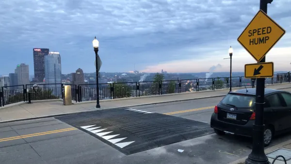
Pittsburgh Excels at Low-Cost, Quick-Build Traffic Calming
The city’s traffic calming initiative has led to a 6 percent average reduction in speeds on corridors with recent interventions.

Planetizen Federal Action Tracker
A weekly monitor of how Trump’s orders and actions are impacting planners and planning in America.

Maui's Vacation Rental Debate Turns Ugly
Verbal attacks, misinformation campaigns and fistfights plague a high-stakes debate to convert thousands of vacation rentals into long-term housing.

San Francisco Suspends Traffic Calming Amidst Record Deaths
Citing “a challenging fiscal landscape,” the city will cease the program on the heels of 42 traffic deaths, including 24 pedestrians.

Amtrak Rolls Out New Orleans to Alabama “Mardi Gras” Train
The new service will operate morning and evening departures between Mobile and New Orleans.

The Subversive Car-Free Guide to Trump's Great American Road Trip
Car-free ways to access Chicagoland’s best tourist attractions.

San Antonio and Austin are Fusing Into one Massive Megaregion
The region spanning the two central Texas cities is growing fast, posing challenges for local infrastructure and water supplies.
Urban Design for Planners 1: Software Tools
This six-course series explores essential urban design concepts using open source software and equips planners with the tools they need to participate fully in the urban design process.
Planning for Universal Design
Learn the tools for implementing Universal Design in planning regulations.
Heyer Gruel & Associates PA
JM Goldson LLC
Custer County Colorado
City of Camden Redevelopment Agency
City of Astoria
Transportation Research & Education Center (TREC) at Portland State University
Jefferson Parish Government
Camden Redevelopment Agency
City of Claremont