


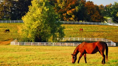
The architectural firm SCAPE plans new paths through Lexington, Kentucky’s downtown using the city's buried water and karst formations as its key features.
There's water flowing underground. Not just in Talking Heads songs, but all over Kentucky. Porous limestone is shaped and passed through by water. This topology is called karst, and it's going to be a key feature in a new series of bike and walking paths in Lexington, Kentucky.
In an article for The Architects Newspaper, Zach Edelson reports the multi-use path, "Will carve pedestrian and bike paths through the heart of Lexington, creating new green spaces and linking with regional trails at both ends. To create freshwater pools—SCAPE calls them “karst windows,” in reference to similar naturally occurring formations—the design will tap old culverts (essentially large pipes) that previously kept Lexington’s karst water out of sight."
While the project is yet to break ground, the designers hope to gain support for the project by tying it to a key feature of Kentucky, the karst topology is what bluegrass sits atop.
FULL STORY: SCAPE turns Lexington, Kentucky’s long-buried water into an asset


Lexington, Kentucky Passes Urban Growth Plan
The city’s new master plan sets out requirements for mixed-use development.
Support for Shrinking the Nation's Oldest Growth Boundary
Lexington, Kentucky's growth boundary survived a comprehensive plan update in 2019, after years of controversy. A housing crisis, a growing city, and a broken land use system are rearranging the political arithmetic behind the greenbelt.
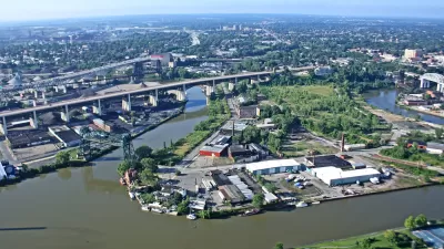
Cleveland Bike Path Plan Leaves Some Locals Unhappy
Change was slow to come to a neighborhood in Cleveland, but not everyone is pleased with what a new riverside bike path will bring with it.

Planetizen Federal Action Tracker
A weekly monitor of how Trump’s orders and actions are impacting planners and planning in America.

Map: Where Senate Republicans Want to Sell Your Public Lands
For public land advocates, the Senate Republicans’ proposal to sell millions of acres of public land in the West is “the biggest fight of their careers.”

Restaurant Patios Were a Pandemic Win — Why Were They so Hard to Keep?
Social distancing requirements and changes in travel patterns prompted cities to pilot new uses for street and sidewalk space. Then it got complicated.

Platform Pilsner: Vancouver Transit Agency Releases... a Beer?
TransLink will receive a portion of every sale of the four-pack.

Toronto Weighs Cheaper Transit, Parking Hikes for Major Events
Special event rates would take effect during large festivals, sports games and concerts to ‘discourage driving, manage congestion and free up space for transit.”

Berlin to Consider Car-Free Zone Larger Than Manhattan
The area bound by the 22-mile Ringbahn would still allow 12 uses of a private automobile per year per person, and several other exemptions.
Urban Design for Planners 1: Software Tools
This six-course series explores essential urban design concepts using open source software and equips planners with the tools they need to participate fully in the urban design process.
Planning for Universal Design
Learn the tools for implementing Universal Design in planning regulations.
Heyer Gruel & Associates PA
JM Goldson LLC
Custer County Colorado
City of Camden Redevelopment Agency
City of Astoria
Transportation Research & Education Center (TREC) at Portland State University
Camden Redevelopment Agency
City of Claremont
Municipality of Princeton (NJ)