


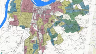
The Mapping Inequality website documents how the liberal ideals of the New Deal devolved into discrimination and inequality.
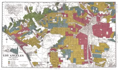
"The maps in this post are part of a grim history," according to an article by Greg Miller. "They were created by a government program in the 1930s and played a role in keeping African Americans and other minorities from owning property in American cities, thereby leaving an indelible mark on the racial and economic history of the United States."
The Mapping Inequality project has gathered these maps and documents, the work of the Home Owners' Loan Corporation (HOLC) during the Great Depression, and placed them online.
Miller explains more of the redlining history of the HOLC, while also sampling specific case studies from cities included in the Mapping Inequality archive—cities such as Los Angeles, Seattle, Wichita, and Portland.
As acknowledged on the Mapping Inequality website, the project combines the work of researchers and students at the University of Richmond, the University of Maryland, Virginia Tech, and Johns Hopkins University.
FULL STORY: Newly Released Maps Show How Housing Discrimination Happened


Reporters Go Undercover to Identify Housing Discrimination
A three-year investigation of the real estate industry on Long Island reveals rampant discriminatory practices and an industry complicit in the segregation of the communities that comprise the region.
Study: Historical Redlining Maps No Longer a Proxy for Black America
Black Americans have moved on from formerly redlined neighborhoods, and other minorities and whites have moved in. The wave of presidential campaigns that have based housing policy proposals on redlining maps might be misguided as a result.

Seattle Exhibit Grapples With Redlining Past and Present
A creative exhibit highlights how redlining and racist exclusion persist today.

Montreal Mall to Become 6,000 Housing Units
Place Versailles will be transformed into a mixed-use complex over the next 25 years.

Planetizen Federal Action Tracker
A weekly monitor of how Trump’s orders and actions are impacting planners and planning in America.

DARTSpace Platform Streamlines Dallas TOD Application Process
The Dallas transit agency hopes a shorter permitting timeline will boost transit-oriented development around rail stations.

Nine Ways to Use Curb Space That Aren’t Parking
California’s new daylighting law bans parking within 20 feet of crosswalks. How can cities best use this space?

ADUs for Sale? San Diego Could Legalize Backyard Condos
As one of 25 proposed amendments, San Diego may soon allow accessory dwelling units to be bought and sold as individual homes.

Dallas Ditches Parking Minimums in 14-1 Vote
The sweeping city council decision removes set parking requirements from developments downtown, near transit, small businesses and more.
Urban Design for Planners 1: Software Tools
This six-course series explores essential urban design concepts using open source software and equips planners with the tools they need to participate fully in the urban design process.
Planning for Universal Design
Learn the tools for implementing Universal Design in planning regulations.
City of Mt Shasta
City of Camden Redevelopment Agency
City of Astoria
Transportation Research & Education Center (TREC) at Portland State University
City of Camden Redevelopment Agency
Municipality of Princeton (NJ)
Regional Transportation Commission of Southern Nevada