


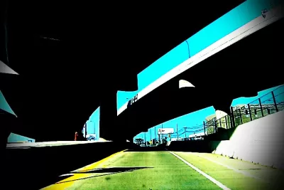
Photographer Michael DeFilippo captures the striking, ironic, and often depressing ways in which highways cut apart the urban fabric of St. Louis.
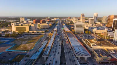
Sixty years ago, the Interstate Highway System blazed into being, a darling of then-President Eisenhower. Today we can appreciate the curses and the blessings of those mammoth constructions, which enable suburbia but often disable the dense urban areas they pass through.
This article gives us some striking photos from another 60-year-old. "Photographer Michael DeFilippo has spent the last five months documenting freeways in his city of St. Louis. He completed the series this week, tied to the 60th anniversary, and ahead of his own 60th birthday Friday."
Kate Abbey-Lambertz writes, "DeFilippo's photos aren't filled with decay, nor do they seem particularly grim at first glance. Many feature historic buildings and city landmarks under bright blue skies. But the freeways are still always present, and there are moments of dark humor."
Amid all the disjointed imagery, DeFilippo's photos depict one new development: a highway cap park. "One of these projects is in St. Louis, a park over I-44 that links the Gateway Arch with the rest of downtown. DeFilippo's series ends with a photo of that connector."
FULL STORY: One Man’s Quest To Document The Highways That Tore His City Apart


Cities Turn to Highway Cap Parks for Economic Development
Some worry that, of the many reasons cities pursue cap parks, creating quality green space is low on the list.
Disconnecting Communities: Measuring the Social Impacts of Freeways
Research from 50 major U.S. cities shows social connections are weakest in neighborhoods where highways are present.
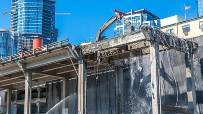
Highway Removal Slowed by Outdated Policy, Lack of Committed Funding
Resistance from state transportation departments and precarious funding sources mean highway removal projects are few and far between, despite their benefits.

Planetizen Federal Action Tracker
A weekly monitor of how Trump’s orders and actions are impacting planners and planning in America.

Chicago’s Ghost Rails
Just beneath the surface of the modern city lie the remnants of its expansive early 20th-century streetcar system.

San Antonio and Austin are Fusing Into one Massive Megaregion
The region spanning the two central Texas cities is growing fast, posing challenges for local infrastructure and water supplies.

Since Zion's Shuttles Went Electric “The Smog is Gone”
Visitors to Zion National Park can enjoy the canyon via the nation’s first fully electric park shuttle system.

Trump Distributing DOT Safety Funds at 1/10 Rate of Biden
Funds for Safe Streets and other transportation safety and equity programs are being held up by administrative reviews and conflicts with the Trump administration’s priorities.

German Cities Subsidize Taxis for Women Amid Wave of Violence
Free or low-cost taxi rides can help women navigate cities more safely, but critics say the programs don't address the root causes of violence against women.
Urban Design for Planners 1: Software Tools
This six-course series explores essential urban design concepts using open source software and equips planners with the tools they need to participate fully in the urban design process.
Planning for Universal Design
Learn the tools for implementing Universal Design in planning regulations.
planning NEXT
Appalachian Highlands Housing Partners
Mpact (founded as Rail~Volution)
City of Camden Redevelopment Agency
City of Astoria
City of Portland
City of Laramie