


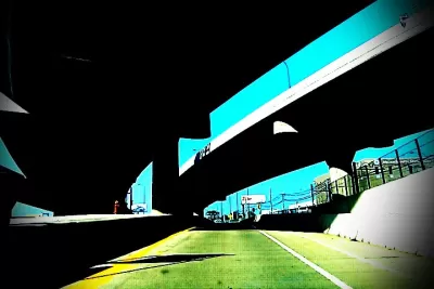
Photographer Michael DeFilippo captures the striking, ironic, and often depressing ways in which highways cut apart the urban fabric of St. Louis.
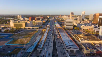
Sixty years ago, the Interstate Highway System blazed into being, a darling of then-President Eisenhower. Today we can appreciate the curses and the blessings of those mammoth constructions, which enable suburbia but often disable the dense urban areas they pass through.
This article gives us some striking photos from another 60-year-old. "Photographer Michael DeFilippo has spent the last five months documenting freeways in his city of St. Louis. He completed the series this week, tied to the 60th anniversary, and ahead of his own 60th birthday Friday."
Kate Abbey-Lambertz writes, "DeFilippo's photos aren't filled with decay, nor do they seem particularly grim at first glance. Many feature historic buildings and city landmarks under bright blue skies. But the freeways are still always present, and there are moments of dark humor."
Amid all the disjointed imagery, DeFilippo's photos depict one new development: a highway cap park. "One of these projects is in St. Louis, a park over I-44 that links the Gateway Arch with the rest of downtown. DeFilippo's series ends with a photo of that connector."
FULL STORY: One Man’s Quest To Document The Highways That Tore His City Apart


Cities Turn to Highway Cap Parks for Economic Development
Some worry that, of the many reasons cities pursue cap parks, creating quality green space is low on the list.
Disconnecting Communities: Measuring the Social Impacts of Freeways
Research from 50 major U.S. cities shows social connections are weakest in neighborhoods where highways are present.
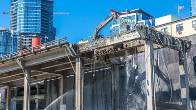
Highway Removal Slowed by Outdated Policy, Lack of Committed Funding
Resistance from state transportation departments and precarious funding sources mean highway removal projects are few and far between, despite their benefits.

Montreal Mall to Become 6,000 Housing Units
Place Versailles will be transformed into a mixed-use complex over the next 25 years.

Planetizen Federal Action Tracker
A weekly monitor of how Trump’s orders and actions are impacting planners and planning in America.

DARTSpace Platform Streamlines Dallas TOD Application Process
The Dallas transit agency hopes a shorter permitting timeline will boost transit-oriented development around rail stations.

Interactive Map Reveals America's “Shade Deserts”
Launched by UCLA and American Forests to combat heat-related deaths, the tool maps the shade infrastructure for over 360 U.S. cities.

Bicycles and Books — In Sacramento, Libraries Now Offer Both
Adult library card holders can check out e-bikes and e-trikes for up to one week.

Colorado Landfills Emit as Much Pollution as 1M Cars
Landfills are the third-largest source of methane pollution in Colorado, after agriculture and fossil fuel extraction.
Urban Design for Planners 1: Software Tools
This six-course series explores essential urban design concepts using open source software and equips planners with the tools they need to participate fully in the urban design process.
Planning for Universal Design
Learn the tools for implementing Universal Design in planning regulations.
City of Mt Shasta
City of Camden Redevelopment Agency
City of Astoria
Transportation Research & Education Center (TREC) at Portland State University
City of Camden Redevelopment Agency
Municipality of Princeton (NJ)
Regional Transportation Commission of Southern Nevada