


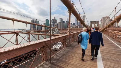
A crowded and hurried scene is becoming more and more common on the pedestrian and bike path that spans the Brooklyn Bridge. So much so, that the city is ready to consider a new, wider path.
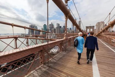
"Think driving the Brooklyn Bridge can be nerve-racking?" asks an article by Winnie Hu. "Try squeezing onto an elevated, wood-and-concrete promenade that runs above its six vehicle lanes."
According to Hu, New York City transportation officials this week announced the launch of a seven-month engineering study of a potential new bike and pedestrian path on the bridge. AECOM will conduct the study, assessing "how much weight the bridge can carry, and consider options for expansion, including widening the existing promenade by building decks on top of the girders that run directly above the car lanes," reports Hu.
FULL STORY: Brooklyn Bridge, the ‘Times Square in the Sky,’ May Get an Expansion

Modal Friction on the Brooklyn Bridge
The popularity of crossing New York City's second oldest bridge by foot and pedal is causing friction between the two modes on the promenade above six lanes of motor vehicle traffic. A report released for NYCDOT proposes recommendations.
First New Bridge to Manhattan in Decades Proposed Just for Pedestrians and People on Bikes
Introducing the proposed Queens Ribbon Bridge, a $100 million idea to connect Manhattan to Long Island City in Queens, by way of Roosevelt Island.

Work Begins To Improve Brooklyn Bridge Bike Lane
The city plans to make conditions safer for bikes and pedestrians on and around the Brooklyn Bridge bike lane, which opened to much fanfare—and some disappointment—last year.

Planetizen Federal Action Tracker
A weekly monitor of how Trump’s orders and actions are impacting planners and planning in America.

Chicago’s Ghost Rails
Just beneath the surface of the modern city lie the remnants of its expansive early 20th-century streetcar system.

San Antonio and Austin are Fusing Into one Massive Megaregion
The region spanning the two central Texas cities is growing fast, posing challenges for local infrastructure and water supplies.

Since Zion's Shuttles Went Electric “The Smog is Gone”
Visitors to Zion National Park can enjoy the canyon via the nation’s first fully electric park shuttle system.

Trump Distributing DOT Safety Funds at 1/10 Rate of Biden
Funds for Safe Streets and other transportation safety and equity programs are being held up by administrative reviews and conflicts with the Trump administration’s priorities.

German Cities Subsidize Taxis for Women Amid Wave of Violence
Free or low-cost taxi rides can help women navigate cities more safely, but critics say the programs don't address the root causes of violence against women.
Urban Design for Planners 1: Software Tools
This six-course series explores essential urban design concepts using open source software and equips planners with the tools they need to participate fully in the urban design process.
Planning for Universal Design
Learn the tools for implementing Universal Design in planning regulations.
planning NEXT
Appalachian Highlands Housing Partners
Mpact (founded as Rail~Volution)
City of Camden Redevelopment Agency
City of Astoria
City of Portland
City of Laramie