


The city plans to make conditions safer for bikes and pedestrians on and around the Brooklyn Bridge bike lane, which opened to much fanfare—and some disappointment—last year.
A Streetsblog NYC article details the New York City Department of Transportation’s efforts to improve the highly anticipated Brooklyn Bridge bike lane, which disappointed some bike advocates when it opened last year.
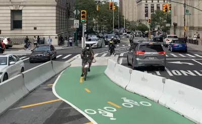
“Currently, the stretch of Centre Street north of Worth Street is what cyclists call ‘The Sluice’ because it resembles an entry path into an abattoir. Both curbside lanes of the roadway are occupied with placarded court and law enforcement cars.” According to the article, “The slaughterhouse conditions continue northbound on Centre Street to Canal Street. But the roadway definitely does not get safe above Canal. Yes, there is less double parking, but frustrated drivers tend to speed above Canal, where Centre opens up to two wide, rarely obstructed lanes.” Due to these conditions, “Since January 2017, there have been 64 reported crashes on just the two-block stretch of Centre Street between Canal and Grand streets, injuring eight cyclists, three pedestrians and two motorists.”
Now, “Work is under way to extend the Brooklyn Bridge protected bike lane on Centre Street north of Worth Street all the way to Kenmare Square and add a downtown-bound protected bike lane on Lafayette Street south of Kenmare Square, which currently has a painted lane.” Additionally, “The city will cut the motor vehicle lanes on Centre Street from two down to one in the section between Worth and Canal, and had previously said it would install pedestrian island[s] at every intersection along the way (some of those have already been blocked out).”
The plan doesn’t address every issue: “The only thing missing from this gap-closing plan is a better solution for cyclists who want to ride between the Brooklyn Bridge bike path and points west, including the hugely popular Hudson River Greenway.”
FULL STORY: Eyes on the Street: The Dawn of a Better Brooklyn Bridge Bike Lane!

Judge Halts Brooklyn Bike Lane Removal
Lawyers must prove the city was not acting “arbitrarily, capriciously, and illegally” in ordering the hasty removal.
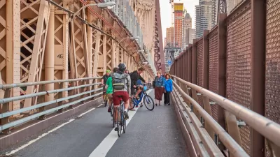
Bike Traffic Up 88 Percent On New Brooklyn Bridge Bike Lane
Bike ridership nearly doubled after New York City installed a new bike lane on the Brooklyn Bridge.
Brooklyn Bridge Bike Path Could Be Wider, Safer
Advocates want to see a safer plan for the proposed two-way path on one of the country's busiest commuter corridors.

Maui's Vacation Rental Debate Turns Ugly
Verbal attacks, misinformation campaigns and fistfights plague a high-stakes debate to convert thousands of vacation rentals into long-term housing.

Planetizen Federal Action Tracker
A weekly monitor of how Trump’s orders and actions are impacting planners and planning in America.

In Urban Planning, AI Prompting Could be the New Design Thinking
Creativity has long been key to great urban design. What if we see AI as our new creative partner?

King County Supportive Housing Program Offers Hope for Unhoused Residents
The county is taking a ‘Housing First’ approach that prioritizes getting people into housing, then offering wraparound supportive services.

Researchers Use AI to Get Clearer Picture of US Housing
Analysts are using artificial intelligence to supercharge their research by allowing them to comb through data faster. Though these AI tools can be error prone, they save time and housing researchers are optimistic about the future.

Making Shared Micromobility More Inclusive
Cities and shared mobility system operators can do more to include people with disabilities in planning and operations, per a new report.
Urban Design for Planners 1: Software Tools
This six-course series explores essential urban design concepts using open source software and equips planners with the tools they need to participate fully in the urban design process.
Planning for Universal Design
Learn the tools for implementing Universal Design in planning regulations.
planning NEXT
Appalachian Highlands Housing Partners
Mpact (founded as Rail~Volution)
City of Camden Redevelopment Agency
City of Astoria
City of Portland
City of Laramie