


A new study shows what happens when cities remove red light cameras, which have become targeted by many motorists and eliminated by at least 158 cities. Fatal crashes increased 30 percent compared with area cities that kept the controversial cameras.
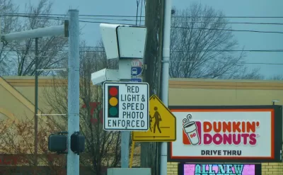
Do traffic crashes, including those that cause deaths, increase after a city pulls their red-light cameras due to motorists' complaints? Yes, according to a new study released by the insurance industry. It is also the first study to analyze what happens after red light cameras are removed.
"The Insurance Institute for Highway Safety looked at 14 cities that ended their red-light camera programs between 2010 and 2014," reports Phil LeBeau, CNBC auto reporter. "Researchers compared the annual crash rates in those cities with those of 29 others in the same regions that continued using red-light cameras."
In those cities that turned off their cameras, the rate of fatal crashes involving a driver who sped through a red light was 30 percent higher per capita than if the cameras had remained functional, according to the research.
Most of those killed by red-light-running vehicles are not the drivers, but passengers, pedestrians and bicyclists, the IIHS said.
The study indicates that 158 communities have stopped using red-light cameras in the last five years, reports Joan Lowy for the Associated Press.
"Debates over automated enforcement often center on the hassle of getting a ticket and paying a fine," IIHS President Adrian Lund said.. "It's important to remember that there are hundreds of people walking around who wouldn't be here if not for red-light cameras.
"Red light camera programs in 79 large U.S. cities saved nearly 1,300 lives through 2014," according to the IIHS press release.
The study can be accessed from the on-line abstract.
FULL STORY: They may be annoying, but red-light cameras save lives: IIHS

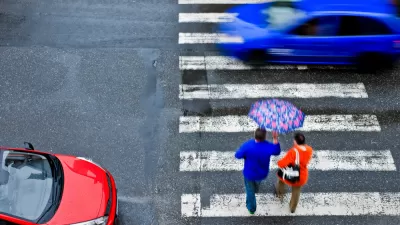
Pedestrian Deaths Last Year Projected to Be Highest Since 1990
Among the factors that stand out in the "Spotlight on Highway Safety" report released Thursday by the Governors Highway Safety Association is increased "death by SUV," which kill at a higher rate than cars. Distraction, however, is hard to prove.

Red Light Cameras Receive Endorsement from Influential Governors' Group
Calling it 'mind boggling' that municipalities are removing 'proven safety tools,' the Governors Highway Safety Association strongly endorsed the use of the controversial red light cameras to 'to improve safety for all road users.'
Automotive Braking Improvements: Pedestrian and Cyclist Benefits Included
NHTSA's announcement that automatic emergency braking will become standard on almost all new vehicles by 2022 will have dramatic safety implications for drivers and passengers, but will it prevent crashes with pedestrians and cyclists?

Planetizen Federal Action Tracker
A weekly monitor of how Trump’s orders and actions are impacting planners and planning in America.

Map: Where Senate Republicans Want to Sell Your Public Lands
For public land advocates, the Senate Republicans’ proposal to sell millions of acres of public land in the West is “the biggest fight of their careers.”

Restaurant Patios Were a Pandemic Win — Why Were They so Hard to Keep?
Social distancing requirements and changes in travel patterns prompted cities to pilot new uses for street and sidewalk space. Then it got complicated.

Platform Pilsner: Vancouver Transit Agency Releases... a Beer?
TransLink will receive a portion of every sale of the four-pack.

Toronto Weighs Cheaper Transit, Parking Hikes for Major Events
Special event rates would take effect during large festivals, sports games and concerts to ‘discourage driving, manage congestion and free up space for transit.”

Berlin to Consider Car-Free Zone Larger Than Manhattan
The area bound by the 22-mile Ringbahn would still allow 12 uses of a private automobile per year per person, and several other exemptions.
Urban Design for Planners 1: Software Tools
This six-course series explores essential urban design concepts using open source software and equips planners with the tools they need to participate fully in the urban design process.
Planning for Universal Design
Learn the tools for implementing Universal Design in planning regulations.
Heyer Gruel & Associates PA
JM Goldson LLC
Custer County Colorado
City of Camden Redevelopment Agency
City of Astoria
Transportation Research & Education Center (TREC) at Portland State University
Camden Redevelopment Agency
City of Claremont
Municipality of Princeton (NJ)