


The University of Texas Arlington's Institute of Urban Studies is doing to legwork for an update of the Downtown Dallas 360 master plan.

A team of researchers and doctoral students from the University of Texas at Arlington's Institute of Urban Studies "are embarking on a first-of-its-kind study on the walkability of downtown Dallas," according to an article by Brandon Formby.
Formby sets the stage for the research, which takes place in a "downtown whose activity once withered at the end of the workday is now peppered with burgeoning hot spots of residential, recreational and retail vitality."
Hoping to account for the elements already contributing to the success of Downtown Dallas, "[collecting] data to identify and map which city blocks have the highest concentration of pedestrians, the safest crosswalks and the most well-maintained sidewalks."
"In all, the team will collect data on about 30 different urban design features for each street segment," adds Formby. The article provides context for the study in the form of the growing body of literature on the importance of walkability to a number of desirable outcomes. Formby also drills down into specifics of urban design, such as shade trees.
FULL STORY: Counting trees? Downtown Dallas taking steps to be more pedestrian friendly

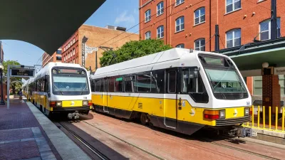
North Texas Transit Leaders Tout Benefits of TOD for Growing Region
At a summit focused on transit-oriented development, policymakers discussed how North Texas’ expanded light rail system can serve as a tool for economic growth.

Dallas Considers Nixing Parking Requirements
According to one local official, Dallas projects routinely build 20 to 30 percent more parking than they need, driving up the cost of housing and leading to unsustainable land use patterns.

Dallas Extends Permit for Downtown Drive-Thru
The city has indicated this is the last time it will extend a permit for a drive-thru at a McDonald’s restaurant as it transitions to supporting a denser, more walkable downtown environment.

Planetizen Federal Action Tracker
A weekly monitor of how Trump’s orders and actions are impacting planners and planning in America.

San Francisco's School District Spent $105M To Build Affordable Housing for Teachers — And That's Just the Beginning
SFUSD joins a growing list of school districts using their land holdings to address housing affordability challenges faced by their own employees.

The Tiny, Adorable $7,000 Car Turning Japan Onto EVs
The single seat Mibot charges from a regular plug as quickly as an iPad, and is about half the price of an average EV.

Seattle's Plan for Adopting Driverless Cars
Equity, safety, accessibility and affordability are front of mind as the city prepares for robotaxis and other autonomous vehicles.

As Trump Phases Out FEMA, Is It Time to Flee the Floodplains?
With less federal funding available for disaster relief efforts, the need to relocate at-risk communities is more urgent than ever.

With Protected Lanes, 460% More People Commute by Bike
For those needing more ammo, more data proving what we already knew is here.
Urban Design for Planners 1: Software Tools
This six-course series explores essential urban design concepts using open source software and equips planners with the tools they need to participate fully in the urban design process.
Planning for Universal Design
Learn the tools for implementing Universal Design in planning regulations.
Smith Gee Studio
City of Charlotte
City of Camden Redevelopment Agency
City of Astoria
Transportation Research & Education Center (TREC) at Portland State University
US High Speed Rail Association
City of Camden Redevelopment Agency
Municipality of Princeton (NJ)