


The deployment of so-called defensive architecture is in the news again. This time the controversy is in the public realm, as San Francisco considers a fence to keep homeless out of McCoppin Hub.
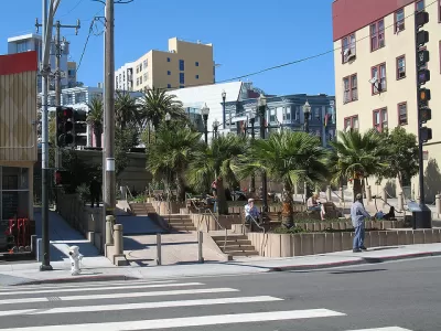
"There are many proposed solutions for the city’s homeless problems: more housing, more treatment, more funding, more tough love," writes Adam Brinklow. "The latest proposal is a fence around a troubled plaza."
The fence in question would go up around McCoppin Hub, a public square near Market and Valencia Street.
Local blogger Michael Petrelis broke the news that McCoppin Hub will be fenced in as an anti-homeless measure by Labor Day.
Brinklow sums up the trouble with using a fence as a deterrent to the homeless:
There would appear to be a built-in contradiction here: If the plaza is a public space, the public should presumably have access to it. "Installing this fence will not only keep the homeless out, it will keep all the rest of us locked outside too," the Sisters of Perpetual Indulgence complained in an online petition circulated last year.
The article also includes a poll to ask readers whether they support the fence. At the time of this writing, 472 respondents have weighed in on the question, with 61 percent saying the fence should go up.
FULL STORY: Poll: Should the City Fence the Homeless Out of Plazas?

The Resurgence of Anti-Homeless Policy and Design
A report by researchers at the University of California, Berkeley tracks the proliferation of vagrancy laws in the Golden State. Meanwhile, The Guardian notes the spread of so-called "defensive architecture."
On the Value of Small Spaces in Remaking the Public Realm
San Francisco Chronicle Architecture Critic John King reviews, and celebrates, the recent string of small projects that reclaim public space in the city, calling them "modest works of true ambition."
Why You Can Never Find a Bench in San Francisco
Over the last two decades the city of San Francisco has systematically removed its public benches to fight homelessness. Now citizens are clamoring for their return.

Planetizen Federal Action Tracker
A weekly monitor of how Trump’s orders and actions are impacting planners and planning in America.

Congressman Proposes Bill to Rename DC Metro “Trump Train”
The Make Autorail Great Again Act would withhold federal funding to the system until the Washington Metropolitan Area Transit Authority (WMATA), rebrands as the Washington Metropolitan Authority for Greater Access (WMAGA).

DARTSpace Platform Streamlines Dallas TOD Application Process
The Dallas transit agency hopes a shorter permitting timeline will boost transit-oriented development around rail stations.

San Francisco's School District Spent $105M To Build Affordable Housing for Teachers — And That's Just the Beginning
SFUSD joins a growing list of school districts using their land holdings to address housing affordability challenges faced by their own employees.

Car-Centric LA Suburb Looks to a Train-Oriented Future
City leaders in Rancho Cucamonga, the future western terminus of the Brightline West rail line to Las Vegas, want to reimagine the city as a transit-oriented, pedestrian-friendly community.

New Alaska Bitcoin Mine Would Burn as Much Energy as the State’s Largest Coal Plant
Fueled by “stranded” natural gas, the startup hopes to become the largest in the US, and to make Alaska an industry center.
Urban Design for Planners 1: Software Tools
This six-course series explores essential urban design concepts using open source software and equips planners with the tools they need to participate fully in the urban design process.
Planning for Universal Design
Learn the tools for implementing Universal Design in planning regulations.
Municipality of Princeton
Roanoke Valley-Alleghany Regional Commission
City of Mt Shasta
City of Camden Redevelopment Agency
City of Astoria
Transportation Research & Education Center (TREC) at Portland State University
US High Speed Rail Association
City of Camden Redevelopment Agency
Municipality of Princeton (NJ)