


As with most natural disasters, it's not a question of 'if' but 'when' when it comes to the eruption of Mount Rainier in Washington state. Scientists lay out a scenario for what to expect when the volcano erupts.
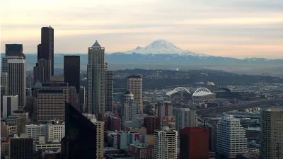
Joshua McNichols of KUOW.org spoke with a local geologist and emergency management employee to find out what residents of northwest Washington state could expect when Mount Rainier finally erupts. Geologist Carolyn Driedger anticipates that beyond the lava and giant boulders launched into the air, the real calamity will result from the melted snow which would create flash flooding down the mountain. The resulting mudflows, or lahar, would do massive damage to the surrounding environment.
No one knows how big a lahar would be for Mount Rainier – or how far it would travel. But [Scott Heinze, with the Pierce County department of emergency management] wants to show me how far it could come. He takes me to Fireman’s Park, high on a bluff above the port of Tacoma. “You can see the cranes over there,” he says. “You can see the rail yard, you can see 167 and I-5, a steady stream of semis that are coming in and out of port.” Everything we see, he told me, could be drowned by a lahar. Routes connecting Tacoma to Seattle could be buried. Tacoma could face shortages of food and supplies. Many of its hydroelectric dams and water sources also lie in lahar zones.
Heinze advises people to get off the valley floor quickly and to have an evacuation route planned out ahead of time. He anticipates that the chaos from the evacuation will lead to more fatalities.
FULL STORY: What will happen when Mount Rainier erupts?

‘Quality Work, Fast’: NC Gears up for Homebuilding After Helene, Trying to Avoid Past Pitfalls
The state will field bids to demolish, repair and rebuild homes in the mountains. After struggles in eastern NC, officials aim to chart a different course.

Rebuilding After Disaster: The Role of Social Connections in Resilience
Dr. Lucy Jones emphasizes that resilience in the face of climate-driven disasters like wildfires relies on building strong social connections, which empower communities to recover and adapt to an increasingly challenging future.
A Cutting-Edge Planning Hackathon in Seattle
In GeekWire, Chuck Wolfe covers an atypical urban planning and policy gathering called an “Urban Resilience Hackathon,” which was held at the University of Washington in Seattle late last month. For a day, the event showcased collaborative problem solving and innovative thinking in addressing urban challenges.

Planetizen Federal Action Tracker
A weekly monitor of how Trump’s orders and actions are impacting planners and planning in America.

San Francisco's School District Spent $105M To Build Affordable Housing for Teachers — And That's Just the Beginning
SFUSD joins a growing list of school districts using their land holdings to address housing affordability challenges faced by their own employees.

The Tiny, Adorable $7,000 Car Turning Japan Onto EVs
The single seat Mibot charges from a regular plug as quickly as an iPad, and is about half the price of an average EV.

Seattle's Plan for Adopting Driverless Cars
Equity, safety, accessibility and affordability are front of mind as the city prepares for robotaxis and other autonomous vehicles.

As Trump Phases Out FEMA, Is It Time to Flee the Floodplains?
With less federal funding available for disaster relief efforts, the need to relocate at-risk communities is more urgent than ever.

With Protected Lanes, 460% More People Commute by Bike
For those needing more ammo, more data proving what we already knew is here.
Urban Design for Planners 1: Software Tools
This six-course series explores essential urban design concepts using open source software and equips planners with the tools they need to participate fully in the urban design process.
Planning for Universal Design
Learn the tools for implementing Universal Design in planning regulations.
Smith Gee Studio
City of Charlotte
City of Camden Redevelopment Agency
City of Astoria
Transportation Research & Education Center (TREC) at Portland State University
US High Speed Rail Association
City of Camden Redevelopment Agency
Municipality of Princeton (NJ)