


Planners have set their sights on the Little Havana neighborhood of Miami with the goal of turning the area's car-centric Calle Ocho into a ped-friendly Main Street.
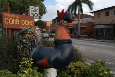
A grassroots effort of community members in Miami's Little Havana neighborhood is trying to wrestle control of their streets from the automobile. Tanvi Misra reports in CityLab that the Florida Department of Transportation has begun studying how to improve mobility options along the community's iconic 8th Street and 7th Street corridor. Community groups and local officials are wary of FDoT's efforts and have begun offering their own solutions to turn the auto-dominated street into a Main Street, where cars get less room and pedestrians have a chance to mingle on wider sidewalks.
Plusurbia, a local urban design and architecture firm, has proposed converting 8th Street from one-way back to a two-way thoroughfare, as it was before the 1950s. The Plusurbia plan also envisions shady trees, bulb-outs, narrower driving lanes and street furniture.
The push to revitalize Calle Ocho comes as Little Havana experiences changes that locals believe threaten its character. The National Historical Preservation Trust put the area on its list of 11 most endangered sites in 2015 because of its dilapidated architecture. As housing prices elsewhere in the city skyrocket, Little Havana’s aging housing stock makes its residents vulnerable to displacement. Plusurbia’s plan, however, would only foster and conserve economic and cultural diversity, the firm says.
FULL STORY: Redesigning the Iconic Thoroughfare at the Heart of Little Havana


A Dutch 'Shared Street' Is Coming To Miami
A Dutch-style "shared street" is being planned in the Wynwood neighborhood of Miami.

Florida DOT Adopts 'Context-Based' Street Design
The "right street in the right place" hasn't always been a concept that departments of transportation were ready to acknowledge, much less adopt. The Florida Department of Transportation, however, is working to take context into consideration.
Florida Backs Miami Complete Streets Initiative
The Florida DOT has approved Miami's plan to rework busy Biscayne Boulevard. In the spirit of Complete Streets, vehicle lanes will be reduced and pedestrian/bike spaces expanded.

Planetizen Federal Action Tracker
A weekly monitor of how Trump’s orders and actions are impacting planners and planning in America.

Maui's Vacation Rental Debate Turns Ugly
Verbal attacks, misinformation campaigns and fistfights plague a high-stakes debate to convert thousands of vacation rentals into long-term housing.

Restaurant Patios Were a Pandemic Win — Why Were They so Hard to Keep?
Social distancing requirements and changes in travel patterns prompted cities to pilot new uses for street and sidewalk space. Then it got complicated.

In California Battle of Housing vs. Environment, Housing Just Won
A new state law significantly limits the power of CEQA, an environmental review law that served as a powerful tool for blocking new development.

Boulder Eliminates Parking Minimums Citywide
Officials estimate the cost of building a single underground parking space at up to $100,000.

Orange County, Florida Adopts Largest US “Sprawl Repair” Code
The ‘Orange Code’ seeks to rectify decades of sprawl-inducing, car-oriented development.
Urban Design for Planners 1: Software Tools
This six-course series explores essential urban design concepts using open source software and equips planners with the tools they need to participate fully in the urban design process.
Planning for Universal Design
Learn the tools for implementing Universal Design in planning regulations.
Heyer Gruel & Associates PA
JM Goldson LLC
Custer County Colorado
City of Camden Redevelopment Agency
City of Astoria
Transportation Research & Education Center (TREC) at Portland State University
Jefferson Parish Government
Camden Redevelopment Agency
City of Claremont