


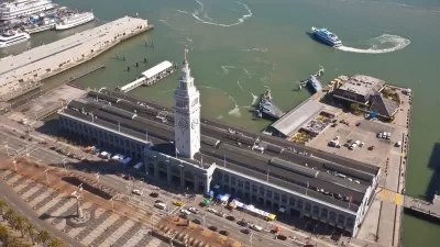
With BART showing its age and struggling to meet growing demand, water-borne vehicles a potential panacea for transit in the San Francisco Bay Area?
"Twenty public ferries serving eight cities shuttle thousands of people across the [San Francisco Bay] every day, but there used to be many more," according to an article by Bryan Goebel. The question posed by Goebel, then, is how the amount of ferry service offered around the Bay Area might be increased to meet historical levels of service, or, for that matter, contemporary demand.
Interestingly, the biggest blow to ferry service in the bay occurred when the Bay Bridge opened in 1936, which also included a train, known as the Key System, when it first opened. In 2016, Goebel reports, "the Golden Gate and San Francisco Bay ferry systems carry more than 16,000 passengers each weekday," and overwhelmed transit and freeway systems in the region might provide the reason for improved ferry service.
Evidence of the growth of ferry service in the Bay Area includes two new ferry terminals expected to open by 2022, the new operations of private ferry companies, and a 20-year draft strategic plan created by planners at the Water Emergency Transportation Authority, according to Goebel.
FULL STORY: Why Isn’t There More Ferry Service in the Bay Area?

San Francisco Takes Steps to Electrify Bay Ferries
In addition to electrifying the fleet, San Francisco Bay Ferry and the Port of San Francisco are building new facilities to connect more communities to the ferry system.
California Lawmakers Withdraw Connect Bay Area Act
The proposal would have merged the Bay Area’s 27 transit agencies into one regional entity.
Poll: Bay Area Voters on Transit Funding Sources
Voters in Northern California indicated support for higher taxes on the wealthy and big companies, rejecting increased property or sales taxes to support transportation projects.

Montreal Mall to Become 6,000 Housing Units
Place Versailles will be transformed into a mixed-use complex over the next 25 years.

Planetizen Federal Action Tracker
A weekly monitor of how Trump’s orders and actions are impacting planners and planning in America.

DARTSpace Platform Streamlines Dallas TOD Application Process
The Dallas transit agency hopes a shorter permitting timeline will boost transit-oriented development around rail stations.

Interactive Map Reveals America's “Shade Deserts”
Launched by UCLA and American Forests to combat heat-related deaths, the tool maps the shade infrastructure for over 360 U.S. cities.

Bicycles and Books — In Sacramento, Libraries Now Offer Both
Adult library card holders can check out e-bikes and e-trikes for up to one week.

Colorado Landfills Emit as Much Pollution as 1M Cars
Landfills are the third-largest source of methane pollution in Colorado, after agriculture and fossil fuel extraction.
Urban Design for Planners 1: Software Tools
This six-course series explores essential urban design concepts using open source software and equips planners with the tools they need to participate fully in the urban design process.
Planning for Universal Design
Learn the tools for implementing Universal Design in planning regulations.
City of Mt Shasta
City of Camden Redevelopment Agency
City of Astoria
Transportation Research & Education Center (TREC) at Portland State University
City of Camden Redevelopment Agency
Municipality of Princeton (NJ)
Regional Transportation Commission of Southern Nevada