


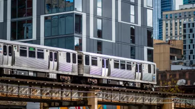
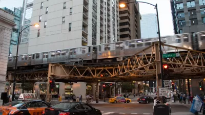
A "TOD Calculator" developed by a Chicago non-profit promises to deliver quantifiable, digestible data on the community impacts of transit-oriented development.

The Grow Chicago "TOD Calculator," created by the Metropolitan Planning Council, uses public data to visualize information on a specific address in Chicago—from its zoning code and proximity to transit, to projections of the annual retail revenue, tax income, on-site jobs, and transit ridership a project built there could generate.
Since its release six months ago, developers, residents, aldermen, and small business owners have used the calculator to judge the impact of potential projects on their own communities.
The data has also influenced regulation—helping convince Chicago to expand its 2013 TOD ordinance by increasing the allowed distance from transit, eliminating parking minimums, and adding density bonuses.
Chicago is hardly the first city to look to open data projects for efficiency, transparency, and shared information to help guide policy. But as Sean Thorton, a fellow with Harvard’s Data-Smart City Solutions initiative, points out, data tech alone is not a magical fix for human, urban problems:
It’s true that without open data, the Calculator would not have been possible to build. Yet MPC’s creative work shows that the effectiveness of data portals themselves also has a ceiling. In order for open data to reach its full potential, those who consume it must be willing to take on complex tasks—like MPC and its partners did—to create tools and products that effectively educate and benefit the public.
The Grow Chicago interactive tool has been joined in recent months by other open data portals, such as OpenGrid in Chicago and GeoHub in Los Angeles.
FULL STORY: How Open Data Can Help Encourage More Transit-Oriented Development

Expanding Chicago TOD Zones Could Boost Transit Ridership
Data indicates broadening the definition of transit-oriented zones to include more of the city would put housing within easy reach of transit for more residents and increase ridership.

Chicago Passes Equitable TOD Ordinance
The new legislation will promote more development near transit in the city’s underserved neighborhoods and improve safety for pedestrians and other road users.
Chicago Grants Support Equitable Transit-Oriented Development
The eTOD program centers equity as a consideration for new projects.

Planetizen Federal Action Tracker
A weekly monitor of how Trump’s orders and actions are impacting planners and planning in America.

San Francisco's School District Spent $105M To Build Affordable Housing for Teachers — And That's Just the Beginning
SFUSD joins a growing list of school districts using their land holdings to address housing affordability challenges faced by their own employees.

The Tiny, Adorable $7,000 Car Turning Japan Onto EVs
The single seat Mibot charges from a regular plug as quickly as an iPad, and is about half the price of an average EV.

Seattle's Plan for Adopting Driverless Cars
Equity, safety, accessibility and affordability are front of mind as the city prepares for robotaxis and other autonomous vehicles.

As Trump Phases Out FEMA, Is It Time to Flee the Floodplains?
With less federal funding available for disaster relief efforts, the need to relocate at-risk communities is more urgent than ever.

With Protected Lanes, 460% More People Commute by Bike
For those needing more ammo, more data proving what we already knew is here.
Urban Design for Planners 1: Software Tools
This six-course series explores essential urban design concepts using open source software and equips planners with the tools they need to participate fully in the urban design process.
Planning for Universal Design
Learn the tools for implementing Universal Design in planning regulations.
Smith Gee Studio
City of Charlotte
City of Camden Redevelopment Agency
City of Astoria
Transportation Research & Education Center (TREC) at Portland State University
US High Speed Rail Association
City of Camden Redevelopment Agency
Municipality of Princeton (NJ)