


South Carolina recently experienced the impacts of what was called a 1,000-year storm. The problem? The state experienced the same level of storm just 26 years ago, and can expect more of the same in the future.
Rob Moore reflects on the lessons from the catastrophic flooding in South Carolina earlier this month, when the state caught the brunt of rains originating from Hurricane Joaquin. According to Moore, change will be necessary in the state's infrastructure and governance to prevent similar disasters.
"The toll in terms of loss of life and damages continues to climb. It will be some time before the flood waters recede and attention shifts to rebuilding, but rebuilding shouldn't just be about putting things back the way they were. The aftermath of an event like this provides an opportunity to think about what to rebuild, where to rebuild, and how to rebuild so we don't just duplicate the same vulnerabilities."
Specifically, adds Moore, the state should update its hazard mitigation plan, which assesses its "vulnerability to future natural disasters" and lays out the "actions it could take to be better prepared." Moore notes that the state last updated that plan in 2013, but relied on some typically inadequate methods for assessing risk. The key point: past data about storms will be inadequate to predict storm events in the climate realities of the future, and what we once thought of as 100-year or 1,000-year storm events will occur with much greater frequency.
FULL STORY: South Carolina floods a wake-up call for the future

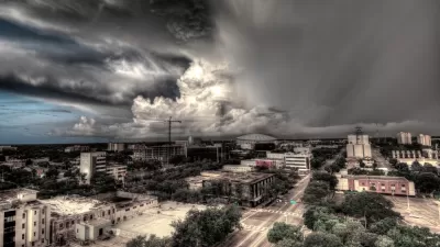
Tampa Bay Isn't Prepared for the Hurricanes of the Future
The area is especially vulnerable to storm surge, and increased development means more people are at risk when major hurricanes push through.
Challenging the Rush to Rebuild
Justin Gillis outlines some harsh criticisms of disaster response efforts that rebuild without rethinking – and how much it's costing taxpayers across the country.
With a Little Help From Their Dutch Friends, Could New York Become New Amsterdam?
“In recent days, the Netherlands’ peerless expertise and centuries of experience in battling water have been widely hailed in the United States as offering lessons" for New York and for other cities alike, writes Andrew Higgins.

Maui's Vacation Rental Debate Turns Ugly
Verbal attacks, misinformation campaigns and fistfights plague a high-stakes debate to convert thousands of vacation rentals into long-term housing.

Planetizen Federal Action Tracker
A weekly monitor of how Trump’s orders and actions are impacting planners and planning in America.

San Francisco Suspends Traffic Calming Amidst Record Deaths
Citing “a challenging fiscal landscape,” the city will cease the program on the heels of 42 traffic deaths, including 24 pedestrians.

Adaptive Reuse Will Create Housing in a Suburban Texas Strip Mall
A developer is reimagining a strip mall property as a mixed-use complex with housing and retail.

Study: Anti-Homelessness Laws Don’t Work
Research shows that punitive measures that criminalized unhoused people don’t help reduce homelessness.

In U.S., Urban Gondolas Face Uphill Battle
Cities in Latin America and Europe have embraced aerial transitways — AKA gondolas — as sustainable, convenient urban transport, especially in tricky geographies. American cities have yet to catch up.
Urban Design for Planners 1: Software Tools
This six-course series explores essential urban design concepts using open source software and equips planners with the tools they need to participate fully in the urban design process.
Planning for Universal Design
Learn the tools for implementing Universal Design in planning regulations.
Heyer Gruel & Associates PA
JM Goldson LLC
Custer County Colorado
City of Camden Redevelopment Agency
City of Astoria
Transportation Research & Education Center (TREC) at Portland State University
Jefferson Parish Government
Camden Redevelopment Agency
City of Claremont