


Seattle continues to expand its efforts to improve walkability with the Safe Routes to School Program.
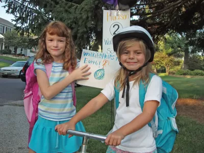
In Seattle, 83 percent of public school students live within their school's official walk zone, but only 24 percent are walking or bicycling to school. "A huge amount of peak-hour traffic is just for school drop-off and pick-up," reports Tom Fucoloro. This creates a catch-22, he explains: parents are afraid to let their kids walk or bike to school, so they drive them, thus contributing to the car traffic and creating a more dangerous space for walkers and bicyclists.
As part of the city's new Vision Zero plan to eliminate all traffic-related deaths, the Safe Routes to School program will be expanded to include 3rd, 4th, and 5th grade education on biking and walking for all public school students; safety improvements for sidewalks and crosswalks; and strategies for long-term infrastructural investments. The plan emphasizes the importance of reduced speed limits, citing numerous statistics comparing the dangers of 20 mph vs. 30-40 mph speed limits. For example, nine out of ten pedestrians hit by a car traveling at 20 mph will survive; only one out of ten will survive the impact at 40 mph.
"The grassroots powering the plan make it one of the best collections of ideas you will find in any road safety plan," writes Fucoloro.
FULL STORY: How Seattle plans to fuel its grassroots walk-and-bike-to-school revolution

The Most Bike-Friendly States in the Nation
The League of American Bicyclists ranks states based on bike infrastructure and safety efforts.
Which Cities Have the Highest Pedestrian Fatalities?
Rapid population growth and limited pedestrian infrastructure puts people walking at higher risk.

Houston Developers Question Mayor’s Stance on Pedestrian Projects
The new mayor’s reversal of road safety projects, some already underway or completed, is raising eyebrows among developers who say residents want walkable, mixed-use streets.

Maui's Vacation Rental Debate Turns Ugly
Verbal attacks, misinformation campaigns and fistfights plague a high-stakes debate to convert thousands of vacation rentals into long-term housing.

Planetizen Federal Action Tracker
A weekly monitor of how Trump’s orders and actions are impacting planners and planning in America.

San Francisco Suspends Traffic Calming Amidst Record Deaths
Citing “a challenging fiscal landscape,” the city will cease the program on the heels of 42 traffic deaths, including 24 pedestrians.

In U.S., Urban Gondolas Face Uphill Battle
Cities in Latin America and Europe have embraced aerial transitways — AKA gondolas — as sustainable, convenient urban transport, especially in tricky geographies. American cities have yet to catch up.

Detroit Says Problems With Property Tax Assessments are Fixed. Advocates Disagree.
With higher-valued properties under assessed and lower-valued properties over assessed, advocates say there's still a problem with Detroit's property tax system.

Defunct Pittsburgh Power Plant to Become Residential Tower
A decommissioned steam heat plant will be redeveloped into almost 100 affordable housing units.
Urban Design for Planners 1: Software Tools
This six-course series explores essential urban design concepts using open source software and equips planners with the tools they need to participate fully in the urban design process.
Planning for Universal Design
Learn the tools for implementing Universal Design in planning regulations.
Heyer Gruel & Associates PA
JM Goldson LLC
Custer County Colorado
City of Camden Redevelopment Agency
City of Astoria
Transportation Research & Education Center (TREC) at Portland State University
Jefferson Parish Government
Camden Redevelopment Agency
City of Claremont