


The Federal Highway Administration may put an end to rules mandating wide lanes and "clear zones," making it easier to implement complete streets.
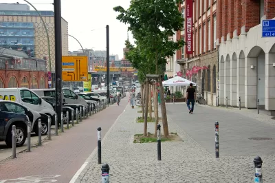
A set of "outdated" rules currently guides street construction, taking inspiration from what works on highways. "In what appears to be a major breakthrough, yesterday the Federal Highway Administration [FHWA] proposed rule changes that will allow cities and towns to more easily design streets in a way that's consistent with an urban setting," according to Angie Schmitt.
The existing rules are a source of delay and frustration when it comes to implementing safer complete street designs. "The FHWA may drop 11 of the 13 design requirements that currently apply to streets in the National Highway System designed for speeds below 50 miles per hour. In place of requirements that dictate things like street width and clear zones, FHWA is encouraging engineers to use judgment and consider the surroundings."
"If the proposed changes are approved, local governments would no longer have to deal with a ton of red tape any time their plans deviate from the highway-inspired standards. As it stands, exemptions are often required if planners want to plant street trees, for example, or reduce vehicular lane widths to fit in bike lanes."
FULL STORY: Feds Propose Major Rule Changes to Eliminate Barriers to Safer Streets


Federal Rule Changes Remove Obstacles to Multi-Modal Streets
The Federal Highway Administration (FHWA) made official a set of rule changes that overthrow an old way of thinking about street design.
Report: Some Rural States Ahead of More Urbanized Ones in Reducing Transportation Emissions
This is a largely unintended consequence of states with lower populations and resources focusing on repairing existing roads and infrastructure rather than expanding and building new roads.

Austin Suburb Launches Walkability Study
Kyle, Texas is developing a Sidewalks Master Plan to improve walking facilities.

Montreal Mall to Become 6,000 Housing Units
Place Versailles will be transformed into a mixed-use complex over the next 25 years.

Planetizen Federal Action Tracker
A weekly monitor of how Trump’s orders and actions are impacting planners and planning in America.

DARTSpace Platform Streamlines Dallas TOD Application Process
The Dallas transit agency hopes a shorter permitting timeline will boost transit-oriented development around rail stations.

Interactive Map Reveals America's “Shade Deserts”
Launched by UCLA and American Forests to combat heat-related deaths, the tool maps the shade infrastructure for over 360 U.S. cities.

Bicycles and Books — In Sacramento, Libraries Now Offer Both
Adult library card holders can check out e-bikes and e-trikes for up to one week.

Colorado Landfills Emit as Much Pollution as 1M Cars
Landfills are the third-largest source of methane pollution in Colorado, after agriculture and fossil fuel extraction.
Urban Design for Planners 1: Software Tools
This six-course series explores essential urban design concepts using open source software and equips planners with the tools they need to participate fully in the urban design process.
Planning for Universal Design
Learn the tools for implementing Universal Design in planning regulations.
City of Mt Shasta
City of Camden Redevelopment Agency
City of Astoria
Transportation Research & Education Center (TREC) at Portland State University
City of Camden Redevelopment Agency
Municipality of Princeton (NJ)
Regional Transportation Commission of Southern Nevada