


Most cities around the world can be broken down into 27 typical patterns of development, according to the work of a researcher at UC Davis.
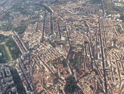
A close study of the street patterns in cities around the world has shown that most cities are comprised of a combination of 27 development categories—from the urban grid typical of downtown cores to superblocks, new urbanist neighborhoods and the "loops & lollipops" suburban style cul-de-sac development. Emily Badger reports in the The Washington Post’s Wonkblog on the work of University of California at Davis professor Stephen Wheeler, who combed over satellite imagery of multiple metropolitan areas around the world to produce striking maps showing the distribution of the varied development patterns.
What's interesting about these 27 categories that Wheeler has defined, covering the full range of development patterns in two dozen metropolitan regions he has studied worldwide, is that most of them are new. Relatively speaking.
"We have had an explosion of different types of built landscapes in the last century," says Wheeler, who is working on a book about these patterns.
Wheeler's work has shown that the most common type of development is primarily associated with suburbs and exurbs—the patterns of development commonly associated with the car. Wheeler believes his work will help people to understand the role that varied development patterns affect "how we travel, how much time we commute, whether we walk, how healthy we are as a result, how our communities affect the climate and how much pollution we generate."
FULL STORY: The 27 patterns that make up the world’s cities and suburbs

Explore US Demographics With the New ACS Atlas Collection
Esri's new ACS Atlas Collection offers interactive applications that visualize the latest U.S. demographic and socio-economic data, enabling users to explore over 175 curated web maps across various thematic areas.

Is the Urban Form Sustainable?
One author offers a framework for resilience that rethinks common assumptions about the inevitability of cities as we know them.

Planetizen’s Top Planning Books of 2023
The world is changing, and planning with it.

Planetizen Federal Action Tracker
A weekly monitor of how Trump’s orders and actions are impacting planners and planning in America.

Map: Where Senate Republicans Want to Sell Your Public Lands
For public land advocates, the Senate Republicans’ proposal to sell millions of acres of public land in the West is “the biggest fight of their careers.”

Restaurant Patios Were a Pandemic Win — Why Were They so Hard to Keep?
Social distancing requirements and changes in travel patterns prompted cities to pilot new uses for street and sidewalk space. Then it got complicated.

Platform Pilsner: Vancouver Transit Agency Releases... a Beer?
TransLink will receive a portion of every sale of the four-pack.

Toronto Weighs Cheaper Transit, Parking Hikes for Major Events
Special event rates would take effect during large festivals, sports games and concerts to ‘discourage driving, manage congestion and free up space for transit.”

Berlin to Consider Car-Free Zone Larger Than Manhattan
The area bound by the 22-mile Ringbahn would still allow 12 uses of a private automobile per year per person, and several other exemptions.
Urban Design for Planners 1: Software Tools
This six-course series explores essential urban design concepts using open source software and equips planners with the tools they need to participate fully in the urban design process.
Planning for Universal Design
Learn the tools for implementing Universal Design in planning regulations.
Heyer Gruel & Associates PA
JM Goldson LLC
Custer County Colorado
City of Camden Redevelopment Agency
City of Astoria
Transportation Research & Education Center (TREC) at Portland State University
Camden Redevelopment Agency
City of Claremont
Municipality of Princeton (NJ)